To the Arctic, part 4. Walruses and icebergs

August 30, 2025 • 9:00 am

This post occupies one day of our trip, again traveling around the big island of Spitsbergen, where’s there is a lot to see.  And it was one of those lovely days when we had activities both in the morning and the afternoon. Morning: a heap o’ walruses; and afternoon: a flotilla of icebergs.

First, a map of the Big Island of the archipelago showing our travels. Spots 1 and 2 mark where we were on this day: St. Jonsfjorden (where we Zodiac’ed around a glacier the previous day), and Poolepynten, Walrus Heaven, both about 78º N latitude:

When I woke up that morning, this was the view outside my cabin window. The iceberg was a harbinger of a good day. Click on the photos to enlarge them.

The Arctic and Antarctic trips have a preplanned schedule, but it always changes depending on weather, wind, waves, and whether there are animals about.  This day’s schedule began with animals, as they excitedly announced on the intercom before breakfast that we’d zodiac to a headland, for they’d spotted a bunch of walruses (I estimate 30-50) hauled out on the beach.  I’d never seen a walrus in the wild, of course, so I was “in a state”.   We took Zodiacs to the shore, and came first upon some seaweed:

Almost every time we went ashore in Spitsbergen, we had to stay close to a guide with a gun. Why? Polar bears, of course, the world’s largest land carnivore, usually hungry, and mean as hell.  Here’s our guide for the walrus viewing.  It was a large-gauge rifle with hollow-point bullets, and all the guides knew how to use it. I think they are not allowed to first at polar bears until they’re 15 meters away and charging (they don’t carry cash). Nobody wants to shoot these magnificent animals and I didn’t meet a guide who had, especially because they are classified as “vulnerable.”

We walked silently and in single file, having been told not to make any noise as walruses have sensitive hearing and are easily disturbed. Voilà: a haul-out with the ship in the background:

Atlantic walruses (Odobenus rosmarus rosmarus) at Poolepynten.  There is only one species but two subspecies. From Wikipedia:

The walrus (Odobenus rosmarus) is a large pinniped marine mammal with discontinuous distribution about the North Pole in the Arctic Ocean and subarctic seas of the Northern Hemisphere. It is the only extant species in the family Odobenidae and genus Odobenus. This species is subdivided into two subspecies: the Atlantic walrus (O. r. rosmarus), which lives in the Atlantic Ocean, and the Pacific walrus (O. r. divergens), which lives in the Pacific Ocean.

Adult walrus are characterised by prominent tusks and whiskers, and considerable bulk: adult males in the Pacific can weigh more than 2,000 kilograms (4,400 pounds) and, among pinnipeds, are exceeded in size only by the two species of elephant sealsWalrus live mostly in shallow waters above the continental shelves, spending significant amounts of their lives on the sea ice looking for benthic bivalve molluscs. Walruses are relatively long-lived, social animals, and are considered to be a “keystone species” in the Arctic marine regions.

They weigh as much as a car.  My camera beeped when it took a shot, but a guide showed me how to turn off the sound, as even a faint “beep” might disturb these beasts. Some walrus snaps:

We weren’t allowed to get too close. Above all, the guides and naturalists are concerned about the animals and the environment, which is great.

Apparently they were cooling off; they do not huddle to stay warm, as they’re encased in blubber. We were told that they simply like to huddle in groups and are comforted by touching each other:

Nice pair of tusks!

After hiking back to the Zodiacs, hovering some distance away, it was already time for lunch. Here are the menus (two for each meal):

Mains: Chicken and spanakopita (there was often foreign food:

Dessert: cassis sorbet and some kind of custard:

After about two hours of rest, it was time for part II of the day: a Zodiac cruise in the bay among the icebergs. You might think that would be boring, but it’s fascinating. All the bergs are different, have different shapes and colors, and often have different patterns from tumbling around in the water. I could easily stay out for several hours, but i think we had an hour and a half. It wasn’t that cold, either. Some bergs (remember, most of them are underwater):

A Zodiac exploring the ice:

The striated patterns in some bergs, we were told, are the results of air bubbles moving upwards when the berg is turned on its side. And yes, they are that blue:

It is an eerie sight, enhanced when the weather is overcast:

Moar:

Every one is different. This one has birds flying by:

Closeup of the previous berg. The patterns and colors are mesmerizing:

There was one very weird berg with rectangular holes in it. Don’t ask me how they got there:

A closeup:

Birds. I can’t identify them; can you?:

More birdies flying around a berg:

The Zodiac driver asked us if we wanted our photos taken in front of an iceberg. I demurred as I don’t like doing such things, but everybody else did, and I was wheedled into doing it:

And then back for another rest followed by dinner. I already was eating too much, so I had a salad (notice the lox):

But I never passed up desserts, and usually had three, these including my favorite: bread pudding with vanilla sauce.

Next episode (in a week): ashore with plants and flowers.

To the Arctic, Part 3. A glacier and its offspring

August 23, 2025 • 9:00 am

Here’s what we saw on the second full day of our trip to the Arctic: a Zodiac cruise in St. Jonsfjorden in Svalbard.  This is what the daily itinerary said:

St. Jonsfjorden is a fjord in Oscar II Land at Spitsbergen, Svalbard. It has a length of 21 kilometer and opens westwards into the strait of Forlandsundet. This is a site with beautiful views of the surrounding mountains and glaciers, and the glacier Gaffelbreen (“Fork glacier”) in a bay just around the corner, interesting tundra with lots of plant species, reindeer and frost-patterned ground can been seen – a lovely little piece of Spitsbergen.

To remind you again, most of our cruising and landing was on the island of Spitzbergen, the largest island in the archipelago known as Svalbard (the whole archipelago was formerly called “Spitzbergen”).  The general location is shown below, with Svalbard in dark green (we were cruising around and landing on the largest island).  We are above the Arctic Circle, which is at 66.5° north latitude, while the archipelago extends from 74° to 81°.

https://upload.wikimedia.org/wikipedia/commons/c/c3/Norway-Svalbard.svg

Here’s a finer-scale map; the small fjord with the red dot is St. Jonsfjorden, and the site has other photos (these are mine).  Gjertsenodden is “a small lowland area on the north side”

First we inspected the Fork Glacier in a Zodiac (inflatable rubber boat). We had a whole hour of cruising, which is a long time in a Zodiac.  First we inspected the glacier face, but couldn’t get too close because it calves off icebergs and can create waves that might overwhelm the boats.

The view from my cabin window as we entered the fjord, with a small glacier visible. Click all photos to enlarge them (recommended):

First, breakfast:

Coming around the corner; you can see the big glacier debouching from the mountain:

A panorama of the Fork Glacier taken from the front of the ship. Click to enlarge!

Two views of the glacier face taken from the ship.

The dark streaks are dirt in the ice that it’s picked up as it moves toward the sea:

Below: the Zodiacs lined up waiting for passengers to climb in. Each one holds a driver and 8-10 passengers, and they can go FAST.  I kept my camera in a plastic bag to keep the seawater out.

We had one hour, a good long time to inspect the glacier and its offspring bergs. Here’s a view of the ship from our Zodiac, with the glacier face to the left:

A berg recently calved from the glacier:

. . . and one floating away:

Our guide leaned over the boat’s edge (not safe!) to pick up a piece of floating ice for us:

I’m holding a piece, and then I tasted it. It was good. Remember, this is frozen fresh water, not ice water. In the Antarctic, at one Ukrainian station they served vodka made with glacier water. Now that is a rarity! Sadly, we didn’t have such a libation in the Arctic.

We were told this was a bearded seal (Erignathus barbatus) resting on a floe. Wikipedia says this:

It gets its generic name from two Greek words (eri and gnathos) that refer to its heavy jaw. The other part of its Linnaean name means bearded and refers to its most characteristic feature, the conspicuous and very abundant whiskers. When dry, these whiskers curl very elegantly,[3] giving the bearded seal a “raffish” look.[citation needed].

I love that “citation needed” for “raffish look”. More:

Bearded seals are the largest northern phocid. They have been found to weigh as much as 300 kg (660 lb) with the females being the largest. However, male and female bearded seals are not very dimorphic

Here’s a Wikipedia photo showing the raffish look. Pretty damn raffish, no? The one above isn’t so raffish. . .

Bearded Seal (Erignathus barbatus), Baltasound marina by Mike Pennington, CC BY-SA 2.0, via Wikimedia Commons

After a hot shower, lunch followed in the Balena restaurant, where they prepared a stir-fry (highly Westernized, though I asked for mine Szechuan style):

And my first visit to the bridge (I went many times) as we left the fjord , showing the surroundings. That was all the day’s activities as we were steaming towards a new location for a landing. Walruses and even better icebergs!

To the Arctic, part 2: The ship, its amenities, and its food

August 16, 2025 • 9:30 am

I really should describe trips as they happen, but this wasn’t possible on my trip to the Arctic as there was no Internet most of the time. Also, for me the impetus to post wanes after the trip is over. So I apologize for not being able to post in real time, but I’ll put up at least one post a week, and promise to cover the whole trip.

I’ve already posted part 1, recounting our arrival in Svalbard  and a tour of the rather anodyne town of Longyearbyen, the capital of the archipelago, here.  Today I’ll talk about about life aboard the ship, and then onto the landings, glaciers, iceberg, birds, walruses (walrii?), polar bears, and so on. The routine was to get up, eat breakfast at about 7:30 or 8, have a landing or a Zodiac cruise immediately thereafter, go back to the ship to shower and rest a bit, eat lunch, and then have another landing or Zodiac (rubber inflatable boat) cruise thereafter.  There were then a few hours before dinner. After dinner you could stay up as late as you wanted, but, given my insomnia (which largely disappears on trips), I read until about 9:30 pm or so before retiring. I thus missed much of the evening frivolity, which included quizzes, competition, and non-frivolous lectures about the Arctic.  Most lectures were in the breaks during the day, and I attended about half of them.

So on to the ship, the Quark vessel Ultramarine, designed specifically for polar voyages. The preceding link gives you plenty of photos of the ship and its features, and here are the specs:

Although it holds 199 passengers, I think there were about 140 on this trip, matching the number of staff and crew, including crew you never see—those dealing with the engines and other technical stuff.

Here’s the Ultramarine. It’s a lovely ship and I had no complaints about the voyage. I had a spiffy cabin (half price, which is why I took this trip), the food was great, and the staff and crew were uber-friendly.

The first thing one has to do after boarding is find one’s cabin. Mine is below. It was not fancy compared to other cabins, but it was plenty fine for me.  After that I explored the ship before people got settled.

Below: my cabin—spacious, comfortable, and with the essential porthole to see outside. It was light nearly 24 hours a day, and I checked that by waking up around 2 a.m. and looking outside. It wasn’t much different from how it looked at noon.

This cabin is meant for two people sharing a queen-sized bed, and on cruises each person sharing the cabin pays the same (substantial) fare, but I got this to myself for the price of a single person. What a deal!

Looking toward the other end with the essential porthole. There was also a t.v., but I turned it on only once and watched a bit of Cleopatra, which I’d recently read about (Burton and Taylor version).

The bathroom was compact but had all the essentials, including that nice hot shower—essential for washing off the cold and grime after a landing. I am visible, too. The shower is not visible, but to the right:

One of the great pleasures of such a trip is waking up and seeing what the view is outside. (The curtains are tightly drawn at night because it’s light outside.)

Two views as we approached Jan Mayen Island, part of Norway. As I said, it’s usually off limits to tourists but our head naturalist, Sarah, knew one of the military guys who, with meteorologists, are the sole occupants of the island, so we got to have a two-hour landing. More on that later:

The island is dominated by the world’s northernmost active volcano, the Beerenberg, which you can see here. It last erupted (a fissure eruption) in 1985.

The peak of the volcano, to the right (again through my porthole) has a snow plume blowing from it. (More pictures of the island in a later post.)

Iceberg Day! I was excited to see this one morning, and later that morning we got in Zodiacs anc cruised for an hour among a number of weird bergs carved off a nearby glacier.

There are four lifeboats, two on each side, and each is huge, provisioned with clothing, food, and other requisites. Lifeboat drill and issuing of lifejackets is one of the first things you do after you settle in. Note the crane used to lower the boats, which are on deck 4.

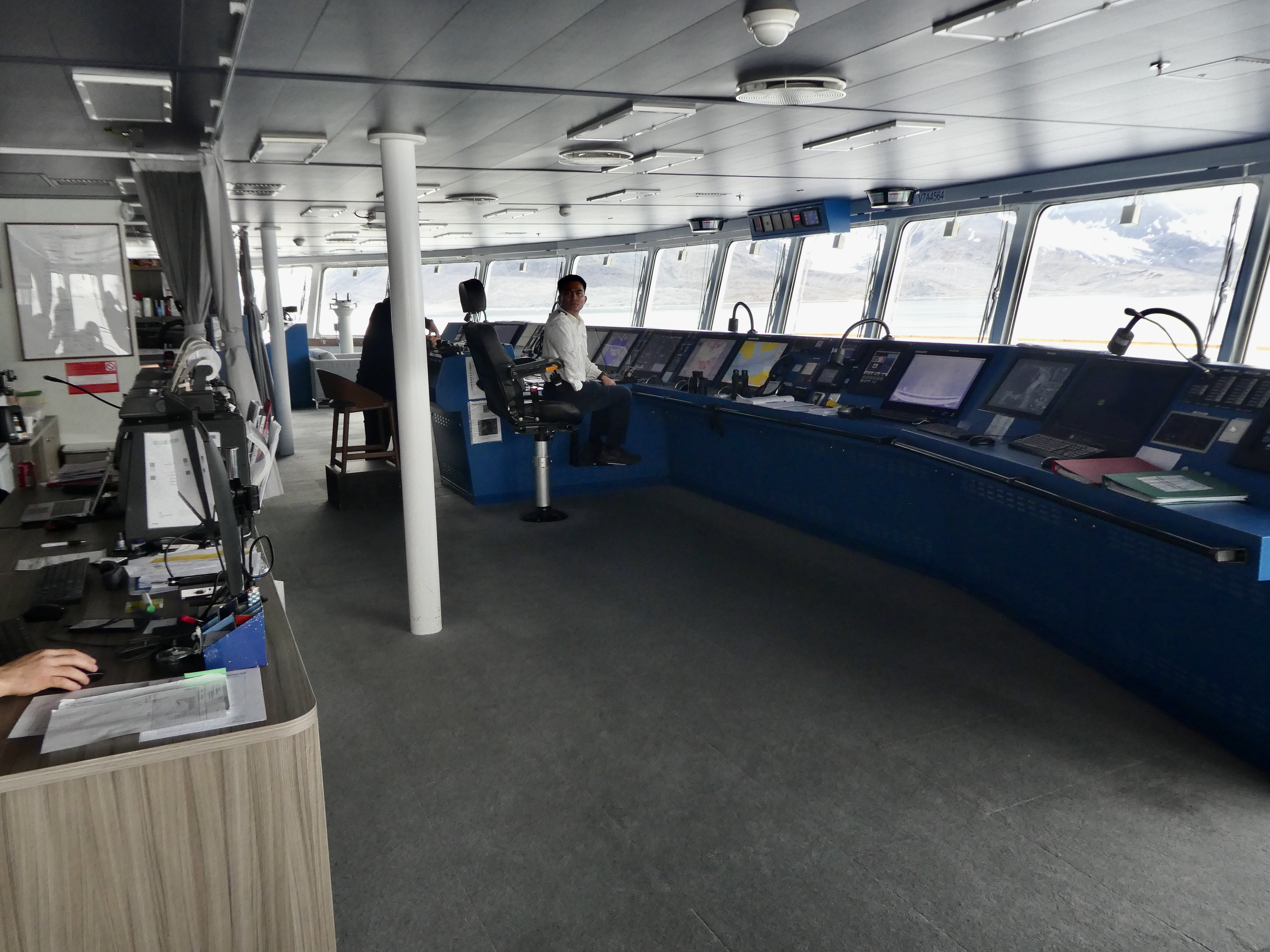
The bridge, with the captain in the front. It’s not like you’d expect; there is no wheel to steer the ship, but a knob. And when the ship is at sea, it’s often on autopilot. On this ship, unlike others I’ve traveled and lectured on, you are encouraged to visit the bridge at nearly all times.

Things get busy when there’s manual steering, as when we’re going through sea ice. Sarah, the head naturalist/guide, is at the right, with the captain to her left:

And the knobs that steer the ship. I believe they are duplicates for redundancy.  THERE IS NO WHEEL, MATEY!

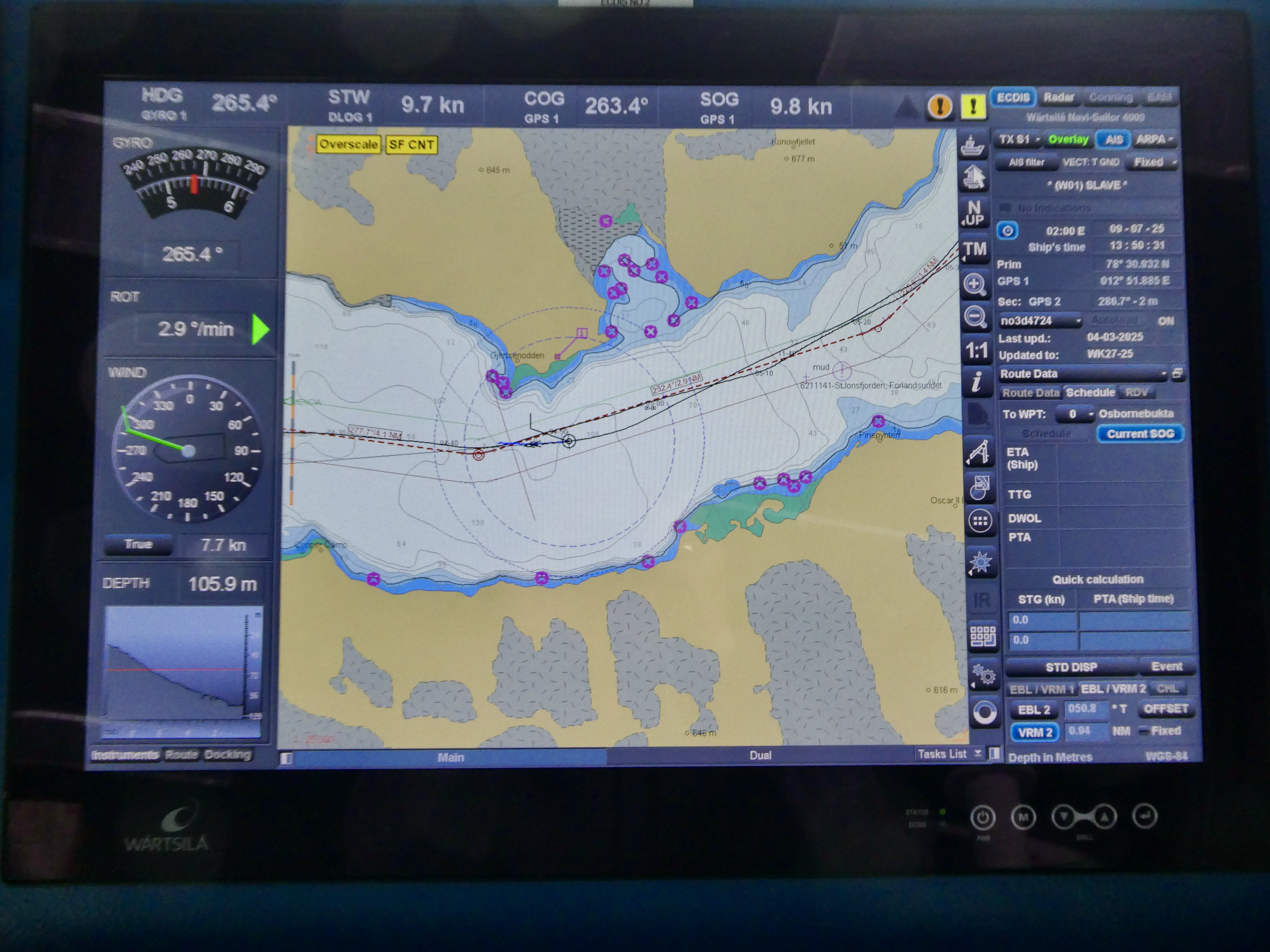
The bridge is full of electronics that display course, depth, surroundings, and so on. Here’s the course display (click all photos to enlarge them).

And here’s the captain, who seemed very young! But I’m sure they wouldn’t put him in charge if he hadn’t proved his mettle. This is taken on the last night of the trip when they have the “Captain’s Farewell”, and all the ship’s personnel parade across the auditorium.  No staff are allowed to drink on the ship, at least not that I saw, so the Captain toasted us with a flute of water.

Part of the parade: the people who make the food: very important people!

The two photos above are in the auditorium, where there are several lectures per day (none by me this time; I was a passenger), as well as the nightly recap and the highly-awaited plans for the next day, which depend on ice, weather, wind, and other factors. Sarah, in charge of the planning, would always have two or three alternatives if we couldn’t do what we wanted. Fortunately, no plans were canceled on this trip: the weather cooperated greatly.

Besides the auditorium, there’s a lovely lounge on Deck 7, with a coffee machine, goodies like cookies and cinnamon rolls set out 24 hours per day, and, when the bar is open, free drinks. I find that i lose my appetite for alcohol when I travel, so I didn’t take full advantage of the booze. I think I had two beers the whole 11-day trip!  There is also a cozy library nook with tons of books about the Arctic and Antarctic (the ship goes south during our winter, when it’s summer in the Antarctic and not much ice to impede traveling). Having been to both areas now, I suppose you could consider me bipolar.

There are screens in the lounge in the front so you can see where we are and the ice and weather conditions.  In slack times, I’d often make my way here, have a cup of hot cocoa and a couple of cookies, and dig into one of the books about the Arctic. And I’d often go on deck to marvel at the scenery or take photos.

Again, you can see many of the ship’s amenities at the Ultramarine link at the top. They also include a sauna, spa, and gym, which I assiduously avoided.

Now on to the feature second in importance only to the scenery and landings, the FOOD.  There are three meals a day, all served in two places: the fancy “Balena” restaurant upstairs, which has buffet service for breakfast and lunch and individual-course service at dinner. There’s also the “Bistro 487,” a few floors up, which serves almost exactly what the Balena serves, but it’s laid out buffet style, three meals a day. I found the Bistro cozier and with better views (fewer tables, all by windows), and a place that was easier to meet people.

So, the menus.  First the Balena’s breakfast menu, displayed outside the restaurant:

Lunch (one menu, two pages):

Lunch, page 2. You can always get a burger if you want

And dinner (two pages):

Desserts are always of great interest to me, and this ship excelled in their quality and variety (see below):

And the Bistro. As I said, the food is pretty much the same as served upstairs, which is expected, but you can serve yourself at all meals. The guy at the end is the Omelet Man who will make you an omelet of your choice at breakfast. One day I asked for my version of a Barney Greenglass special: omelet with eggs, onions, and lox (yes! they had lox!)

Breakfast at the Bistro. Omelet man:

And his wares. In a failed attempt to eat healthy, I had a spinach omelet with vegetables. But there are always freshly scrambled eggs on tap as well. And since there are many Brits, Aussies, and Kiwis aboard, there are sausages, baked beans, blood pudding, and grilled tomatoes, as well as everything else you’d expect for breakfast. I fancied the plain rolls with local butter, which I’d slather with delicious strawberry or lingonberry preserves, which I think were homemade.

Another iteration of my breakfast with fruit, grapefruit juice, a chocolate croissant, a roll, scrambled eggs, and hash browns. So much for eating healthy! But I emphasize that I don’t eat like this at home, where I usually have one meal a day (dinner), along with a latte for breakfast and a light lunch like a grapefruit.

The all-important coffee machine, which grinds the beans on top. I always had two cappuccinos for breakfast. You can see there are eight hot drinks to be had, including cocoa. A waiter was constantly circulating with American-style coffee, but I eschewed it.

LUNCH!  My attempt to create lox and bagel with a schmear:

Most of this is in the Balena restaurant, where I’d often have lunch since it was buffet style. I don’t think I have any photos of dinner, but you can see the Balena’s layout at the Ultramarine link.

Cheese, and lots of it (with crackers). My theory, which is mine, is that Scandinavians like cheese:

The salad bar (only a part of it). There must have been about 20 items you could put on your salad, and always three dressings:

I always started lunch with a salad in my futile attempt to eat healthy. Note the CARBS at the top and some lox that found its way onto my plate:

Salad was followed by another plate, usually light to allow me room for dessert. Here we have some chicken, an unknown food (cottage pie?) at 3 o’clock, a few fries, and spanakopita to the left.

They also offered these luscious stuffed peppers, but I saw them too late—after I’d loaded my plate:

Finally, the crown jewel of the comestibles: desserts. There was always a tray of different fancy desserts, as well as three kinds of ice cream. You need that sugar after a spell among the icebergs! Photos are from both restaurants and from different days.

There is fruit for the timid, but I had my fruit at breakfast:

Bread-and-butter pudding with vanilla sauce. I could not resist!

And the requisite three ice creams, one of them vegan (sorbet, I guess). Here you get a choice of chocolate, pistachio, and apple (vegan) frozen desserts:

I always had at least two desserts, but more often three. Hey, they were small!

Now I didn’t spend all my time eating, nor did I expect this much food, and of such high quality. But it’s vacation, and that means it’s a Free Zone for Gluttony.  In the next photos, I’ll show our landings, glacier cruises on the Zodiac, and animals.

I do recommend the ship highly, and perhaps may take it again. I have a big hankering to go to South Georgia Island, where Shackleton and a few mates went to rescue their crew. But it’s a long haul at sea with nothing in between.  But it has the largest colony of king penguins in the world: 450,000 breeding pairs, or half the world’s population. I need to see that!  They also have many seals and birds, and there Shackleton is laid to rest as well. It’s traditional to have a tot of whiskey by his grave.

To the Arctic: my trip, part 1

August 5, 2025 • 9:00 am

As you know, I recently took an 11-day trip to the Arctic, visiting Svalbard (formerly Spitzbergen), the usually forbidden island of Jan Mayan, and Iceland. Because we didn’t have Internet near the Arctic Circle, I couldn’t send photo or accounts of the trip, so I’ll try to catch up here bit by bit. First, the maps of our trip, courtesy of the folks at Quark Expeditions, who ran the trip on the small (200-passenger, but only 140 aboard) ship the Ultramarine, designed for polar destinations (it’s heading as we speak for Antarctica). As you see, most of the stops were in Svalbard, but there’s plenty to see there.

There are three maps here, each circle indicates a landing or a Zodiac trip. Note #5: our furtheest north; the edge of the Arctic sea ice (see below).

Here’s the daily log at noon from the bridge. As I noted, we got as far north at 82° North Latitude, farther north than the ship, or anybody on it, had ever been (see here for photos).

The first leg of the trip was a flight to Helsinki, Finland where we spent the night in an airport hotel (no time for sightseeing), and then a 3.5-hour flight the next morning to Svalbard, formally a part of Norway.  This archipelago (nearly all islands are uninhabited) is shown in dark green from this Wikipedia map. It’s above the Arctic Circle (60° N).

Rob984, CC BY-SA 4.0, via Wikimedia Commons

We landed at the island’s capital, Longyearbyen, which is touted as the world’s most northerly city with a population of more than 1,000 (it was 2,595 two years ago). The location is shown in red below. As Wikipedia notes, the city “stretches along the foot of the left bank of the Longyear Valley and on the shore of Adventfjorden, the short estuary leading into Isfjorden on the west coast of Spitsbergen, the island’s broadest inlet.” It’s easily accessible by sea, and hence a good place to start a ship tour.

Fleinn, Public domain, via Wikimedia Commons

Now I have to brag that on my trips to Antarctica I also visited all three places touted as “the world’s most southern town“: Punta Arenas, Puerto Williams, and Ushuaia. In latititude the farthest south is Puerto Williams in Chile (54°56′S, 67°37′W, population 1,868), so I can say I’ve been to the most northerly and southerly towns on Earth.

But back to Longyearbyen. It’s a rather dreary place, enlivened only by a few colorful houses and otherwise rather slipshod.  There’s one shopping center where everyone gathers (it has the only grocery store), and I spent several hours there because a wander through the town took about 1.5 hours (they gave us 3.5 hours). I found a cozy chair outside a store and nodded off for a while until our ship, the Ultramarine, left in the afternoon.

It was a cozy ship, unlike the Hurtigruten “Roald Amundsen” on which I lectured and traveled to Antarctica (ca 450 passengers).  The Ultramarine was a delightful vessel, the food was great, the staff was friendly, and, if I can scrape up the dosh, I hope to travel on it again.  Here she be, but more photos of the ship and my cabin will comelater. (Click photos to enlarge them.)

Getting ready to land:

Longyearbyen: our plane from Helsinki. Below that, the first thing you see when you enter the tiny airport terminal, and a sign:

Yes, there are a fair amount of polar bears about, and if you leave the town you’d best carry a gun in case of attack (our guides packed rifles on the trip nearly every time we landed).

Note the “watch out for polar bears” sign. This is not a joke: a woman tourist was killed by a polar bear a few years ago while camping outside near the airport. You do not want to mess with polar bears: they are the largest four-footed predator on Earth, they are totally carnivorous, and they are brazen:

This picture of the town is from Wikipedia; the rest of the photos are mine.  In the background is the former coal-mining operation of the Arctic Coal Company, but that’s been closed for eight years. Instead, as Wikipedia notes, “Meanwhile, the town has seen a large increase in tourism and research. This includes the arrival of institutions such as the University Centre in Svalbard, the Svalbard Global Seed Vault and Svalbard Satellite StationSvalbard AirportSvalbard Church and the Svalbardbutikken department store serve the community.”

And this is pretty much it:

Bjørn Christian Tørrissen, CC BY-SA 4.0, via Wikimedia Commons

The colorful houses are the main draw; here are some:

They are set at the bottom of a hill, which spanwed a big avalanche in 2015 that killed one person and injured 9. I presume the barriers on the mountain were erected later to prevent such events.

While the houses are attractive, behind them people just strew their snowmobiles and skis in big piles, so the city is rather a mess if you snoop around.  But I can see why the residents don’t care much. Big fun in the snow in winter (the aurora is also visible from the city). At this latitude it’s light 24 hours per day, though it gets a bit darker in the middle of the night.

A back porch. Everyone has skis.

Stuff on sale in the grocery store. Besides regular groceries, there’s a big section of tourist-related items featuring the local wildlife:

These are real, and are in the dog food section. (I looked for cat food, but there was none, so I guess there are no cats in Longyearbyen.  I bet that’s because of the bears.)

And I think this is the dreaded RHUBARB, a vegetable I cannot abide. Am I right in my guess?

Wandering disconsolately around the town for the second time, waiting to get on the ship, I heard a honk nearby. And here I found the best part of the city: geese and their goslings! These are barnacle geese, (Branta leucopsis). a species with a range in northern Europe and the Arctic.  I’m not a big fan of geese (ducks are much better), but these are attractive and their fuzzy gray goslings are adorable.

Part of a large group nesting in a field next to the shopping center. There were many more than shown here.

I have to admit that they are good looking:

And with babies!

They were my first wildlife of the trip, and, if I kept a life list, I could have added these babies.  Here’s their range taken from Wikipedia. They are migratory, wintering in the British Isles and northern Europe:

MPF, CC BY-SA 3.0 , via Wikimedia Commons

That made my day, and, in late afternoon, we boarded the ship. The next installment, whenever I get to put it up, will show the ship, my cabin, and the bridge, where we were allowed to wander freely.

Reader’s (my) wildlife photos: Polar bear gnaws dead sperm whale

July 25, 2025 • 10:00 am

One of my “bucket list” goals of going to the Arctic was to see polar bears (also puffins, walruses other birds, and whales). I got them all, but I didn’t get close enough to a puffin.

This photo series, one or two I showed before at much lower resolution, comprises two of these elements: a polar bear and a whale, identified by our whale experts as a sperm whale (I can’t verify this). Near the northernmost part of our trip, at roughly 83º north latitude (a record for the ship itself and everybody on it), we saw an amazing sight: a polar bear (Ursus maritimus) gobbling down the blubber of a dead sperm whale (Physeter macrocephalus) on top of an ice floe. So here you see the world’s largest terrestrial predator gnawing on the world’s largest marine predator.  It is a rarity, as both animals are scarce, and to see them together raised the hair on my neck. It was so amazing! Here are a few shots:

Don’t ask me how a dead whale got on an ice floe rather than sinking in the sea.  This sight alone was, to me, worth the price of the trip. But there was of course a lot more, which I’ll post in the coming weeks. These, though, are my favorite photos. Even an expert polar photographer doesn’t come across situations like this. (Click ’em to enlarge.)

If the resolution leaves a bit to be desired, this was taken with my point-and-shoot Panasonic Lumix DMC ZS60 camera with the lens cranked all the way out to 30X.  I highly recommend this camera for travel, as it fits in your pocket but takes a lot better photos than does an iPhone.

More to come.

I’m going home. . .

July 24, 2025 • 9:30 am

And if you can name the Beatles song that ends with the title of this post, you’ll get my warm congratulations. I’m cooling my heels at the Reykjavik Airport, and just discovered to my horror that IcelandAir does not offer any free food on the flight from Iceland to Chicago, though you can purchase food at an inflated price (see here).

Fortunately, I now have time to prowl the airport for better comestibles.  It’s a normal airport with nothing distinctive, but I did see a very bright rainbow over the sea on my ride here. Normally I’d think that would suggest an upcoming brood of ducks, but it’s too late.

Off to find comestibles. . . .

Unless my plane crashes, you’ll next hear from me from Chicago.

The Golden Circle: three notable spots in Iceland

July 23, 2025 • 7:45 am

Yestday I took an eight-hour bus tour to see the famed “golden circle” of tourist sights near Reykjavic in Iceland.. Wikipedia delineates what we saw:

The Golden Circle (IcelandicGullni hringurinn [ˈkʏtlnɪˈr̥iŋkʏrɪn]) is a tourist route in southern Iceland, covering about 300 kilometres (190 mi) looping from Reykjavík into the southern uplands of Iceland and back. It is the area that contains most tours and travel-related activities in Iceland. The term for the “Golden Circle” was a marketing tactic developed by the Icelandic Tourism board to improve travel.

The three primary stops on the route are the Þingvellir National Park, the Gullfoss waterfall, and the geothermal area in Haukadalur, which contains the geysers Geysir and Strokkur, which erupts every 10-15 minutes. Though Geysir has been mostly dormant for many years, Strokkur continues to erupt every 5–10 minutes. Other stops include the Kerið volcanic crater, the town of HveragerðiSkálholt cathedral, and the Nesjavellir and Hellisheiðarvirkjun geothermal power plants.

Below is a map from Always Around the World of the route we took, which involved about 7.5 hours of total travel and 270 km of driving. Sadly, we went by Keri∂ Crater (a sunken volcanic crater filled with an emerald-green lake), but didn’t have time to see it. We did, however, see lots of the Icelandic countryside, which is flat and grassy, both because it comprises farms but also because the terrain has been flattened by glaciers and the climate is not conducive to trees.

The three sights we visited were Thingvellir National Park, the site where the conjunction of two tectonic plates is most obvious in the world, Geysir, an area of geothermal activity with, yes, geysers, and Gullfoss, one of the most beautiful waterfalls I’ve ever seen (I haven’t been to Niagra).

First, the rift park:

Þingvellir (Icelandic: [ˈθiŋkˌvɛtlɪr̥], anglicised as Thingvellir) was the site of the Alþing, the annual parliament of Iceland from the year 930 until the last session held at Þingvellir in 1798.  Since 1881, the parliament has been located within Alþingishúsið in Reykjavík.

Þingvellir is now a national park in the municipality of Bláskógabyggð in southwestern Iceland, about 40 km (25 miles) northeast of Iceland’s capital, ReykjavíkÞingvellir is a site of historical, cultural, and geological significance, and is one of the most popular tourist destinations in Iceland. The park lies in a rift valley that marks the crest of the Mid-Atlantic Ridge and the boundary between the North American and Eurasian tectonic plates.

I saw no remnants of its parliamentary history, but was delighted to see the signs of the two tectonic plates. I don’t know of any other place on Earth where their conjunction is so obvious. They are moving apart now, at about the rate your fingernails grow: about 1 cm per year.  This movement has created a wide valley containing lake as well as numerous cracks in the earth created as the plates separate. These fissures are all parallel, running from northeast to southwest.

Here’s the rift valley, which we were told is abut 7 km across. You can see the mountains on the other side and the lakes in the valley, while I took the picture from above, on the North American plate:

Here are a few of the fissures in the ground nearby:

This is a big one that people walk through. I have to add that, according to our guide, this was the busiest tourist day this summer. Although it was a Monday, it was sunny and warm: 23º C (73.4° F), and I quickly took off all my outer layers except for a tee-shirt. As you can see below, there were tons of tourists about. It’s summer, July and August are vacation months for the locals, and many of the visitors were Icelandic.

Regardless, I was tremendously excited to see the actual results of plate tectonics, though I’ve seen them before (e.g., the Himalayas). But actually standing on an area where the plates are moving apart was, at least for me, a huge thrill.

On to Haukadalur with its geothermal activity and geysers (I’ve never seen a geyser although the U.S. has the famous “Old Faithful” in Yellowstone National Park).

The geothermal activity is clear even from the parking lot of the visitor center.  Many of these small craters emitting steam also have bubbling hot water. (I have video but can’t post it here; more later.) There are ample warnings to stay away from the water, which is 80-100°C.

Below: the Icelandic geysers compared to others in the world. “Geysir,” the biggie, is no longer active, but Strokkur is, and erupts irregularly with an average about ten minutes. You can see the Strokkur isn’t that much smaller than Old Faithful, but Geysir, when it was active topped them all. I saw about four eruptions of Strokkur (see below). Old Faithful in the U.S. erupts about 20 times a day.

When I asked my guide where the big geyser was, she responded, “Just walk into that area. You’ll know.” And, sure enough, I did:

These people are waiting for Strokkur to erupt, which, as I said, does so irregularly with a mean of about ten minutes.  Because the eruption takes only a second or two, you have to be ready, and it does tire your arms to hold your camera up, focused on the likely eruption spot. I got three shots, with the last missing the top of the largest eruption. It’s a pretty impressive sight (these are three separate eruptions):

And the biggie (I wasn’t prepared for the height):

This is a good YouTube video of what it’s like to be in the area and see the eruptions:

Despite the heat and sulfur, plants and moss grow near the hot effluent. Life is tenacious. Here’s one photo:

Finally, the waterfalls of Gullfoss, as explained in the sign below. Originally it was to be made into a hydroelectric plant, but the locals saved it. Now it’s part of a permanent conservation area:

From Wikipedia:

The Hvítá river flows southward, and about a kilometre above the falls it turns sharply to the west and flows down into a wide curved three-step “staircase” and then abruptly plunges in two stages (11 metres or 36 feet, and 21 metres or 69 feet) into a crevice 32 metres (105 ft) deep. The crevice, about 20 metres (66 ft) wide and 2.5 kilometres (1.6 mi) in length, extends perpendicular to the flow of the river. The average amount of water running down the waterfall is 141 cubic metres (5,000 cu ft) per second in the summer and 80 cubic metres (2,800 cu ft) per second in the winter. The highest flood measured was 2,000 cubic metres (71,000 cu ft) per second.

As it was a rare day of full sun, I had the luxury of seeing a rainbow at these lovely falls. The roar is impressive, and the falls go down in several steps.  I have video but again you’ll have to wait to see that. But I’ve put a video below. First, a few photos I took of the falls. Notice the rainbow (and plethora of tourists):

Here’s a video which gives you a sense of what it’s like to be near this enormous waterfall: Even a gazillion tourists couldn’t drown out the roaring:

A plant I photographed nearby. Botanists: what is it?

And three superfluous photos. First, a teeshirt in the gift shot at Gullfloss (all the tchotchkes are the same in all the shops). Notice the accuracy: the third puffin, which is Paul on the Abbey Road cover, is barefoot, just as Paul was:

Yesterday’s gull levitating a roll with its bill. The gull must have been magical:

And my post-trip reward: ice cream (hazelnut and crème brûlée).  Guess what it cost? But, as Hemingway would say, ‘I deserved it, and it was good.”