I have been here only a bit more than two days, so I can’t claim to know Reykjavik, but I have seen a lot of the downtown after two several-hour walks. l It is not a big town: Wikipedia claims that Reykjavik (the world’s northernmost capital of any sovereign state) has a population of just 139,000 as of 2025, and “the surrounding Capital Region has a population of around 249,000, constituting around 64% of the country’s population.”
Summer is tourist season, and so the streets are crawling with visitors like me, and you hear English spoken everywhere. The fluency of every Icelander I’ve met in English is of course a boon to the visiting Anglophone. All you need is a credit card to survive here, as I haven’t found a place yet, including taxis and coffee shops, that doesn’t take cards, even for tiny purchases. I have $100 in Icelandic krona that I still haven’t spent.
Tomorrow I leave town to go on a bus tour of some of the famous sights of SW Iceland, though I doubt the Blue Lagoon, a famous geothermal spa, will be open because of the recent fissure eruption of a nearby volcano. So it goes.
I’m not yet sure if I’ll make it to the famous Iceland Phallological Museum, devoted to displays of penises, which several readers have suggested I visit. If I go, the highlight will be the plaster cast of Jimi Hendrix’s member as produced by the late Cynthia Plaster Caster (there’s a photo of the junk on her Wikipedia page). But there are also preserved penises and baculums from many animal species. There are no vaginas, and I suspect it would be hard to construct a female equivalent of this museum. I’m told that most of the visitors to this museum are in fact women, though I would have thought that men would predominate, eager to compare their size with that of other species. (There is only one genuine human penis in the museum, a preserved member of a 95-year-old man who swore he employed it sexually until the end.)
In the meantime, here are some random photos I took on my meanderings this morning and early afternoon, with one or two from the day before yesterday.
First, where I am staying: a “guest house” (more like a hostel, which is what it’s called on the sign) north of downtown. The rooms are small and spartan, but believe me, I’ve seen much worse (viz., India and Turkey). But, like all things Icelandic, they are pricey, even compared to the U.S. The price (ca. 750 Euro for my five nights) at least includes a breakfast (croissant, roll, jam, butter, orange juice, cheese, and a tangerine) placed in a bag outside my door each morning. To supplement the brekkie, I went grocery shopping at “Bonus,” supposedly the cheapest supermarket in Iceland,
Photos of a more touristic nature (e.g., the cathedral) will follow when I have time to put them up.
My hostel/guesthouse:

My cozy room. There are no amenities like t.v., but I never watch it anyway (even on the ship), and I’m happy with my book and the Internet:

There is a coffee room where you can cook your own food (this makes it more hostel-like than guesthouse-like), but as for getting a decent cup of coffee, it’s well nigh impossible. There is coffee and a complicated machine, but no milk and no spoons that I could find. My first goal, then, was to find coffee on my morning walk.

When I strolled into town, the first thing I saw was a Starbucks, and I was drawn into it as if by Jupiter’s gravity to quaff a large latte. Behold a $10 Icelandic latte below. In contrast to American lattes at Starbucks (which I rarely patronize), it had a design on top. It also seemed larger.

Judging by the prices of burgers, beer, fish and chips, and other items whose prices I’m familiar with, the Icelandic price is usually between two- and three-fold higher than the American. Now most goods have to be imported here, so that’s understandable, but I’m told that the salaries of locals are not commensurately higher. Perhaps it’s because the country has an extensive social safety net, so people don’t get saddled with stuff like high medical bills, but I’m not qualified to pronounce on economics.
Below: voilà—a $7.66 box of Cheerios in the cheapest supermarket in Iceland. I have no idea what Cheerios cost in America, but I’m sure it’s less than this. If you understand Icelandic, give us the translation below.

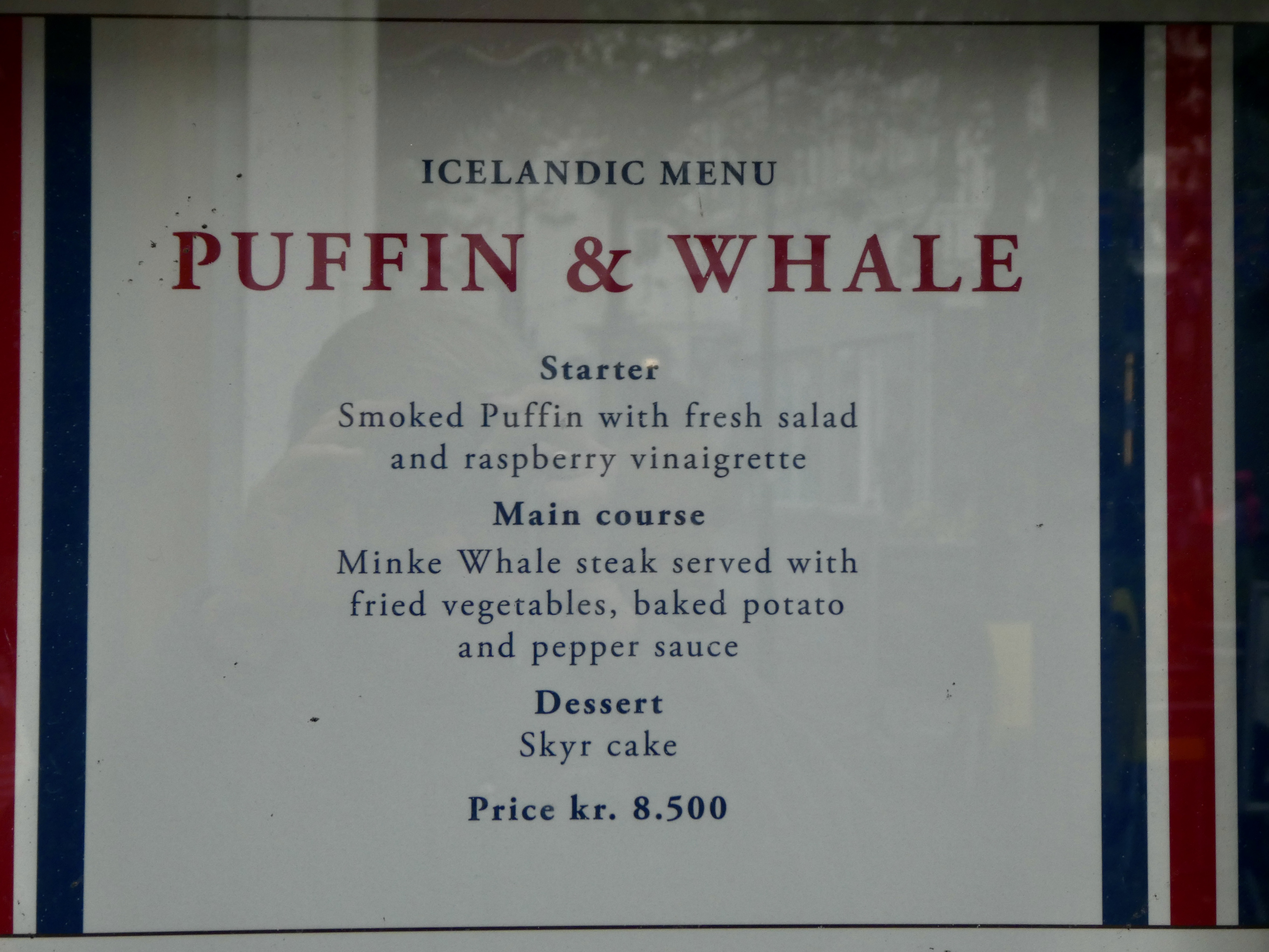
Below: an “Icelandic menu” at one restaurant featuring a SMOKED PUFFIN APPETIZER (Fratercula arctica) and an MINKE WHALE STEAK (Balaenoptera acutorostrata). Iceland is the only country in the world where it’s legal to hunt puffins, and the species is classified as “vulnerable.” Iceland also allows restricted hunting of whales, with 209 fin whales and 217 minke whales permitted to be killed each year for the next five years. Along with Norway and Japan, Iceland is one of only three countries in the world that allow whaling.
Our ship’s naturalists warned us about menus like this, and of course I’ll stay a mile away from them (n.b.: anyone who tells me that avoiding whale and puffin but eating cow makes me a hypocrite better tread very lightly!)
“Skyr” is a smooth Icelandic dairy product described as somewhere between yogurt and curd cheese. I bought a large container of mango skyr to have as dessert.
Two animals I saw on the streets today. First, a lovely gull resting on a cafe table. I don’t know the species, but am sure at least one reader will (identify it in the comments, please):

And a semi-friendly gray tuxedo cat which let me pet it, though it wandered off after a minute or so. It is the first live cat I’ve seen since I left the U.S. Notice that it has the same tough Viking-esque expression as the Reykjavik cat sent in by a reader yesterday.

One of the first things you notice wandering about is the presence of both murals and artistic graffiti. The former are commissioned, while the latter appear on isolated and hidden walls, but are still more artistic than graffiti murals I’ve seen in the U.S. and Europe.
First, some graffiti, which includes a fearsome felid. This was on an abandoned building:

And the entire side of the building (click to enlarge):

Murals are everywhere, expressing political sentiments or advertising businesses. The artists are given due credit at the lower right of each mural. Here’s one of the former painted by two Ukrainian artists and an artist from Iceland, all honoring Icelandic/Ukrainian friendship and Icelandic hospitality towards displaced Ukrainians:

And the explanation:

. . . and murals decorating businesses:

Two views of a store:

Is this a female Viking? Wings seem to be a leitmotif in these murals.

A vampire mural:

And a lovely bird mural. Again, someone will have to identify it for me:

A rainbow-decorated cafe:

And a nearby brasserie advertising its wares:

Finally, as far as I can see, Reykjavik is not a town of gaudy and expensive houses, though there may be a section for such homes. Most streets, however, are fairly bare and spartan, though some of the houses are painted bright colors. Since these streets are around the downtown area (and these are typical streets in that area), it supports the view that Icelanders don’t have salaries commensurate with the high cost of living:


Remember, this is a superficial tourist’s take on what I saw as I wandered about. More photos as I take ’em, and the natural history will come after I return to Chicago.


