Why Evolution is True is a blog written by Jerry Coyne, centered on evolution and biology but also dealing with diverse topics like politics, culture, and cats.
Today we have photos of Finland from ecologist Susan Harrison of UC Davis. Susan’s captions and IDs are indented and you can enlarge them by clicking on them.
Midsummer in the Åland Islands, Finland
On the tiny Åland Islands in the Baltic Sea, humans observe Midsummer Eve in traditional Swedish style. Towering, vine-decorated maypoles are raised in an hourlong process of pole-pushing and rope-pulling, followed by folk music and dancing.
Midsummer Eve at around 9 pm, Kastelholm, Åland:
Birds, meanwhile, have even more urgent preoccupations than celebrating the summer solstice. Parents are feeding screaming chicks, who jostle for the front of the chow line.
Mute Swans (Cygnus olor) pulling up seaweed for their cygnets:
Great Crested Grebes (Podiceps cristatus) providing transportation and food delivery:
Common Terns (Sterna hirundo), one pair feeding their sole chick fish and insects, while absent adults at the neighboring nest are awaited by two noisy chicks:
Jackdaws (Coloelus modedula), adult and ravenous juvenile:
Barnacle Geese (Branta leucopsis) defending their young against a passing human:
Black Woodpecker (Dendrocopus major), foraging to feed chicks that I didn’t manage to capture in this picture:
These species all have identical or near-identical sexes who share in raising the young, in contrast to the many bird species in which males are flashier and contribute less at the nest than females.
Yesterday involved a lot of walking, much of it with no destination, but I did get in 12,000 steps. Our plan was to take a two-hour walking architecture tour at 9:30, followed by a search for lunch. Unfortunately, my friend Tim got lost on our walk to the tour’s starting point, and we missed the whole tour. The plan then changed to an attempt to have lunch at the famous Mrs. Wilkes’ Dining Room, an all-you-can eat dining experience with great Southern food. But we missed that, too: we found we could change our architecture tour to 1 p.m., and so missed the first seating at Mrs. Wilkes’s.
So it was back to Ogelthorpe Square for the second tour attempt, which succeeded. In between, we grabbed a forgettable lunch at a Mexican restaurant and some excellent ice cream at a famous place.
First, the street where we’re staying again: Jones Street, which our tour guide called “The most beautiful street in Savannah”, lined as it is with oak trees and old houses:
And a portion of the long line at Mrs. Wilkes’. This is an every day occurrence as the place is famous and it doesn’t take reservations. After one seating, you have to wait until a table vacates (you sit with nine strangers) before you can get in, and we missed the first seating. In the meantime, Tim managed to get us on the 1 p.m. tour without paying extra.
After lunch, the first stop was Leopold’s Ice Cream, founded in 1919. From Wikipedia:
In August 2004, Leopold’s moved to its present home on East Broughton Street, in Savannah’s downtown, where it is known for regularly having a line of customers waiting outside. Stratton Leopold hired Hollywood production designer Dan Lomino to recreate his father’s soda fountain from the original store. The ice cream is made, using the same recipes developed by his father and uncle, at a former wholesale florist building at 37th and Price Streets and brought over to the store as necessary.
Leopold’s signature flavor is tutti frutti, a favorite of Savannah’s Johnny Mercer, who worked in the shop as a ten-year old, sweeping floors, while former U.S. President Jimmy Carter’s favorite was the butter pecan. Carter wrote the foreword to Leopold’s Ice Cream: A Century of Tasty Memories, 1919–2019 (Melanie Bowden Simón, 2020).
The outside:
The inside; I didn’t see a soda fountain (perhaps this counter is the remains), but they had a gazillion flavors of ice cream. And yes, there was a line outside.
The newest flavors were also listed outside, and I immediately decided to get the top two, neither of which I’d had before:
My double scoop of lavender and cherry blossom (I ascertained first that they used real flowers). It was terrific: high in butterfat content, dense, and with very subtle flavors. Two scoops after lunch made me walk slower on the architecture tour!
Our first stop was the house of Juliette Gordon Low (1860-1927), who married an uncaring git named William Mackay Lowe, who often cheated on her. During her long periods of being alone, Low learned metalworking, pottery, and other skills. She in fact made this wrought-iron gate at her house:
Low had a tumultuous life, and was almost cheated out of her inheritance as her husband left his money to his mistress. But the will was successfully contested, Low got the dosh, and looked for a worthy project to occupy her. Her project was to found the American Girl Guides, which became the Girl Scouts of America. Eighteen girls were enrolled, and the organization continues today.
Below is a photo from Wikipedia labeled, “Juliette Gordon Low (center) standing with two Girl Scouts, Robertine McClendon (left) and Helen Ross (right).” They’re all in Girl Scout uniform. We were told that every summer Girl Scouts from all over America make a pigrimate to visit Low’s house in Savannah.
Public domain via Wikimedia Commons
Here’s the tallest structure in downtown Savannah, the Independent Presbyterian Church, with a steeple that’s 227 feet and 6 inches tall. Now, by law, no structure in the town can be higher than four stories. They take their historic preservation seriously here.
The bench where Forrest Gump (Tom Hanks) catches a floating white feather (symbolizing the “randomness” of fate) was located right next to the church above, but although the bench was a Hollywood prop and is no longer there, tourists still come in droves to be photographed at the bench site. That famous scene is below:
A typical scene: Southern live oak (Quercus virginiana) covered with Spanish moss (Tillandsia usneoides), a flowering epiphyte that’s neither a moss nor Spanish.
Another epiphyte on an oak tree, Pleopeltis sp. or “resurrection fern,” The AI Google search explains the name:
The resurrection fern (Pleopeltis polypodioides) is named for its remarkable ability to survive long periods of drought by curling up its fronds, turning grey-grown, and appearing dead. When exposed to moisture—even just a little water—it rapidly uncurls and turns vibrant green within 24 hours, appearing to “resurrect”.
There is a drought in Savannah now, so you see the fern in its moribund state:
Below is the Green-Meldrim Mansion, built in 1853 and a National Historic Landmark. The photo below the house explains its historical significance as Union General Sherman’s headquarters in Savannah (upper floor, two window to the right). While Sherman burned much of Georgia during his infamous 1864 March to the Sea that pretty much ended the Civil War, he spared Savannah because it expelled its Confederate troops and surrendered to the Union Army.
Click to enlarge:
One of the many buildings of the Savannah College of Art and Design (SCAD), one of the world’s most famous art schools. Their philosophy is to have art taught by those who make art, not by academics, and I’m told they have a 99% placement rate of its graduates. The school is so wealthy that it participates in Savannah’s ongoing efforts to buy and refurbish historic buildings exactly as they were: a laborious and expensive effort.
In fact it occupies many of the buildings it’s bought and refurbished: this is Poetter Hall, the National Guard Armory in the late nineteenth century. It was SCAD’s first academic building.
A monument to (and burial place) of Casimir Pulaski, a Pole who moved to America and fought for the colonial army during the American Revolutionary War, saving George Washington’s life. He’s a much beloved Polish-American.
Below is the Mercer House (now the Mercer House Museum), completed in 1868. It’s famous for reasons set out in Wikipedia:
The house was the scene of the 1981 killing of Danny Hansford by the home’s owner Jim Williams, a story that is retold in the 1994 John Berendt book Midnight in the Garden of Good and Evil. The house is also featured in the movie adaptation of the book, released three years later. Williams held annual Christmas parties at Mercer House, on the eve of the Savannah Cotillion Club‘s debutante ball, which were the highlight of many people’s social calendars. Williams had an “in” box and an “out” box for his invitations, depending on whether or not the person was in Williams’s favor at the time.
The site of the killing was the room on the first floor whose window is bottome left.
Williams went through four trials for the killing, but no jury in Savannah would convict this popular man, so he esceped punishment, though he did spend some time in jail awaiting trial.
The house was build by the great-grandfather of lyricist Johnny Mercer (“Moon River,” “And the Angels Sing,” “You Must Have Been a Beautiful Baby,” etc.) but nobody named Mercer ever lived in the house.
Because of the movie “Forrest Gump,” Midnight in the Garden of Good and Evil, and the subsequent movie, tourism in Savannah has increased by several-fold in recent years.
Another Historic District house. I can find its picture on Google Image Search, but not its name:
The Armstrong-Kessler Mansion, once owned by Jim Williams (see above): a lousy panoramic shot due to the absence of a viewpoint that didn’t endanger me. From Wikipedia:
The Armstrong Kessler Mansion (formerly known as Armstrong House) is a nationally significant example of Italian Renaissance Revival architectural style located in the Savannah Historic District. The structure was built between 1917 and 1919 for the home of Savannah magnate George Ferguson Armstrong (1868–1924). It was owned by the Armstrong family from 1919 to 1935. Afterward, the structure and grounds served as the campus of Armstrong Junior College. Threatened with demolition, the Historic Savannah Foundation purchased the Armstrong House along with five other threatened historic buildings from the college for $235,000 in 1967. Once saved, Historic Savannah Foundation sold the Mansion (and Hershel V. Jenkins Hall) at the exact purchase price to preservationist and antique dealer Jim Williams who restored it as his home. Eventually, both were sold to a major Savannah law firm as offices.
It’s HUGE and has lovely gardens that are not open to the public. Our guide got to see them, though, and showed us photos.
Finally, a Jew church in Savannah! Yes, a Gothic Revival style synagogue, the only one I know of. Congregation Mickve Israel was founded in 1735, almost immediately after Savannah was settled. It was formed by Sephardic Jews and is now a reform temple . The building dates from 1876, and is built to look like a church as the Jews didn’t want to stick out in Christian Savannah.
A note from Wikipedia:
The Congregation was the first Jewish community to receive a letter from the President of the United States. In response to a letter sent by Levi Sheftall, the congregation’s president, congratulating George Washington on his election as the first President, Washington replied, “To the Hebrew Congregation of the City of Savannah, Georgia”:
… May the same wonder-working Deity, who long since delivering the Hebrews from their Egyptian Oppressors planted them in the promised land – whose providential agency has lately been conspicuous in establishing these United States as an independent nation – still continue to water them with the dews of heaven and to make the inhabitants of every denomination participate in the temporal and spiritual blessings of that people whose God is Jehovah.
“That people whose God is Jehovah”—as opposed to those people whose God was the REAL God!
The plaque outside (click to enlarge).
We had no food ot note yesterday save the ice cream, but in about an hour from this writing we’re off to Mrs. Wilkes’s Boarding House for a gigantic Southern meal
Well, I got my tuches to Savannah at about noon yesterday, and it was already steaming hot. Since our Air B&B didn’t open until 4 pm (why so late?), I had to cool my heels somewhere for a few hours, so I decided to visit the Telfair Museum (a trio of museums downtown), buy a pass, check my bags, get some food, and return for some art-gawking before making my way to the apartment (conveniently located in downtown Savannah).
I parked my luggage at the Jespson Museum, got a recommendation for lunch, and slowly ambled through the famous squares of downtown Savannah to the Little Duck Diner (!), which looks exactly like the picture at the link. It’s duck-themed and serves duck in various guises, but of course I eschewed the waterfowl dishes. Here’s how it looks from the outside:
A logo from the menu (artist unidentified).
The menu is here, and I asked the waiter for recommendations, which is how I came up with the avocado grilled cheese sandwich, with two types of cheese, bacon, avocado, and tomato. I ordered iced tea, and was asked “plain or sweet?”. You know you’re in the South when they ask you that, and of course I got the sweet tea, which, as usual, was so sweet it was almost like liquid dessert. That’s how the “table wine of the South” is served. Lunch:
On my walk to the restaurant, I noticed a small hole-in-the-wall store that sold only cobblers and variations on banana pudding—two dessert specialities of the South—and stopped in to plug the dessert-shaped hole in my being. Again, the place had a duck motif!
The place was The Peach Cobbler Factory, of which there are several branches After ascertaining that the Peach Cobbler was made from canned peaches (fresh fruits are out of season), I had the banana pudding instead. It was a generous portion of that Southern treat, embedded in which were two vanilla wafers (obligatory) and a huge hunk of red velvet cake. It was excellent, and filled the remaining lacuna in my stomach:
I passed this restaurant after lunch, which had a truly Southern seafood menu (click to enlarge). I must get shrimp and grits on this trip. And I would die for some boiled (green) peanuts, which are delicious and which I’ve had only in Georgia
Oy, was it hot! I ambled back to the Jepson Center (one of the trio of museums), where they featured the art of Ossabaw Island, one of the 100 or so Sea Islands near the coast of Georgia (Savannah’s on the ocean). Like most of these, Ossabaw is accessible only by ferry and guided tour. I’m keen to visit Sapelo Island, the home of the last community of Gullah people, a group of black Southerners with their own language and distinctive culture. (They were, of course, enslaved before and during the Civil War.) Here’s an example of the Gullah language, also called Geechee, a creole language that mixes English and African words:
The art was local, but I was most interested in two paintings by Kahlil Gibran, a Lebanese emigrant whom most of us geezers know as a mystic and author of The Prophet(1923), a collection of quasi-mystical fables that many hippies and New Agers revered as “wisdom”. It was immensely popular and has been translated into many languages, but I wouldn’t recommend reading it.
I was surprised to learn that Gibran actually regarded himself more as an artist than a writer, and two of his paintings were at the museum. The first is a self portrait, which I photographed. The details of the painting are in the second photo below:
And a portrait of Gibran’s mother. The guy was a pretty good painter!
An artist from Ossabaw island painting in the Museum and photographed from above:
I might as well put up some photos from Botany Pond, as the ducklings will have hatched when I return (I timed this trip badly, but had no idea that Vashti would be nesting now). The eggs should hatch today or tomorrow, and apparently one was rejected from the nest, as it was found below it but some distance from the ledge.
First, turtles. I’ve now seen all five, so they survived the winter, and they love to bask on the rocks. I believe that there is one yellow-bellied slider (Trachemys scripta scripta) and two red-eared sliders (Trachemys scripta elegans; they are subspecies) in the photo below.
We call this “turtle yoga”:
Nuzzling:
The pair of wood ducks(Aix sponsa) are there nearly every day, but they really should be mating and nesting. We have no tree holes at the pond (a sine qua non for this species to breed), so I have no idea what they’re doing. They are gorgeous, though.
The male (I haven’t named either one):
And the female:
Finally, Vashti on her nest. I’m worried that when the ducklings hatch, they and Vashti will be assaulted by the undocumented drakes who visit the pond. It’s probably good that I’m gone, as I’d be beside myself with anxiety. I have two very reliable associates who are taking care of the waterfowl in my absence.
Note that the nest is lined with soft feathers that she plucked from her breast.
(Armon is still here, ineffectually trying to drive away interloper drakes.)
A close up. Vashti is immobile when on the nest, so I can get quite close to her, but do so only to ensure that she’s still there (she’s hard to see):
Today we have some travel and wildlife photos from reader Jan Malik. Jan’s captions are indented, and you can enlarge the photos by clicking on them. (Don’t miss the Taiwan barbet!)
Here are a few pictures I took during my short stay in Taipei, Taiwan (Republic of China) in 2016. Business trips usually allow very little time for sightseeing — the familiar, morbid cycle of airport → hotel → conference room → hotel → airport — but on this occasion I had a few free hours in the afternoon. Naturally, I decided to explore the nearby Taipei Botanical Garden with a birding lens that mysteriously strayed into my suitcase:
On my way to the Botanical Garden, I visited the National Chiang Kai-shek Memorial Park and Hall, the latter built in the late 1970s after the President’s death. I include it here for documentary reasons — who knows how long it is going to survive, given the volatile political situation.
Inside stands a larger‑than‑life sculpture of the Generalissimo. Taiwan’s history is typical of right‑wing dictatorships which, like South Korea, Spain, or Portugal, began as oppressive authoritarian regimes and then evolved into genuine democracies. Conversely, left‑wing dictatorships typically resist fundamental change and persist until their eventual collapse:
Onward to wildlife. The entrance to the Mausoleum was guarded by a lion (Panthera leo var. lapideus):
Already in the Botanical Garden, I encountered a cat, doing what cats do best – contemplating:
In one of the alleys I came upon a sizable crowd — people were observing local celebrities, a pair of nesting Oriental magpie‑robins (Copsychus saularis). The birds seemed completely unfazed by the attention, the male singing and standing guard at the nest;
These birds are bold and well adapted to human habitats. The female does most of the feeding; here she brings an unidentified moth to her chicks in a rotted‑out branch stump:
At a nearby pond I spotted a duck. It was likely a domestic bird, possibly with a dash of wild Mallard (Anas platyrhynchos) ancestry:
The pond was full of lotus plants, which provided excellent habitat for the Common moorhen (Gallinula chloropus). Like all rails, these birds have relatively small wings and strong feet, well suited to foraging on land as well as in water. They swim well despite lacking webbing between their toes. These traits help explain why, when rails successfully colonize remote predator‑free islands, they often evolve reduced flight or complete flightlessness;
Moving further along the park alleys, I spotted a Taiwan barbet (Psilopogon nuchalis) looking out of its nest cavity. As an endemic species, it was a special find for me. Barbets vary widely in sexual dimorphism — in the Taiwan barbet the sexes are practically indistinguishable, in others (like the Coppersmith barbet) the differences are subtle, and in still others (such as the Red‑and‑yellow barbet) they are striking. I wonder why, in this species, bright coloration in females is not maladaptive. Perhaps the fact that they are obligate cavity nesters shields incubating females from predators. The same logic applies to woodpeckers, whose sexes are also similar aside from modest red patches in males:
Shortly after the barbet, I hit another jackpot in my endemics count — the Taiwan blue magpie (Urocissa caerulea). Like other corvids, it is social and omnivorous, and like Taiwanese barbets, it is sexually monomorphic. Corvids also evolved cooperative breeding: fledglings often remain with their parents and help raise the next brood. This likely evolved through kin selection. Why does it work so well in corvids and not in most other birds? Perhaps in environments with limited resources, young birds have better reproductive success by helping relatives than by attempting to breed independently?:
Having spent some time observing the magpie, I moved on — my remaining time before the flight was getting short. Soon I saw another first for me, though a common sight in Southeast Asia: the light‑vented bulbul (Pycnonotus sinensis). An omnivorous bird, here it was about to snatch a ripe fig:
Moving on, I photographed a dragonfly, which I believe is a male Crimson Marsh Glider (Trithemis aurora). These insects are sexually dimorphic, with olive‑colored females. This male appears to be orienting its abdomen toward the sun to reduce the surface area exposed to solar radiation and prevent overheating — a behavior known as “obelisking”:
Near the Botanical Garden exit I saw the last animal in this series, the Eurasian tree sparrow (Passer montanus). They always bring a smile to my face. Unlike many other sparrows, the sexes are alike. In 1958 they were targeted during China’s “Four Pests” campaign, a fine example of how ideology can override basic biological understanding:
While driving toward the airport that evening, I saw a Buddhist temple by the roadside, adorned with a symbol that, in European cultural circles, evokes entirely non‑religious sentiments. It was adopted in the 1920s by the National‑Socialist German Workers’ Party, but in Asia it is an ancient religious emblem. It is not identical to the Hakenkreuz — it “rotates” counterclockwise — and its meaning here is entirely benign:
Reader EdwardM has sent us some travel photos from Sri Lanka. His captions are indented, and you can click on the photos to enlarge them.
These photos are of statuary and frescoes in the Dambulla Cave Temples outside Kandy, Sri Lanka. Kandy, by the way, has a venerated shrine which holds one of Buddha’s teeth! The Dambulla Cave Temples date to the first century AD. The caves, which sit high on a bare rock escarpment, were used as a refuge for a king, called Valagamba, and his people during one of the many invasions of Sri Lanka. To commemorate their survival, Valagamba and heirs founded a monastery in the caves. Over the centuries images, frescoes, and statues of the Lord Buddha, the bodhisattvas, and various gods and goddesses were installed. Typically they were funded by wealthy Sri Lankans for their private redemptive purposes, much like many Christian sites were funded by the wealthy in hopes of favor or forgiveness. The caves are full of these wonderfully vibrant icons.
The caves themselves were welcoming, with soft light and wonderfully cool air; a respite from the brutal Sri Lankan midday heat. One note I’d like to add. Sri Lanka is a fabulously beautiful land, and I know it has had a complex past with much turmoil and violence. But I became endeared to the people; they are delightful and they get genuine pleasure from other people’s happiness. They aren’t faking it. I loved the country, the people, and I encourage anyone who can go; visit.
Here are a few of the shots from the complex. There are five caves but two of them we closed for work when we were there. First, a reclining Buddha with statues of minor gods and goddesses at his head and one of the bodhisattvas (I have no idea which) seated at left. The Buddha was carved out of the rock in the cave. There are several of these at Dambulla.
This image gives an idea of the size of this reclining Buddha. This one is not the largest in the complex. Amazing that this is carved from the rock itself:
Some more statuary. These are depictions of the bodhisattvas, the enlightened followers of Buddha. Unlike the reclining Buddhas, most of the statuary was NOT carved from the rock of the cave, but was instead carved outside the caves and installed within:
The monks (it’s an active monastery) place offerings to various gods and goddesses. Here they put these fabrics on statues of a couple of the Enlightened, but I don’t recall the significance:
More shots of statuary:
The walls and ceilings were covered in beautiful frescoes, some ancient. Here are a few shots:
Please send your photos, as I have only one set left!
Athayde Tonhasca Júnior is here with photos of a trip to a special place in Greece. Athayde’s captions are indented, and you can enlarge his photos by clicking on them.
Between Heaven and Earth
Meteora (Μετέωρα) is a majestic rock formation comprising countless peaks, caves, crevices and overhangs in the Thessaly region, northern Greece, a 3.5-hour or so drive from Thessaloniki:
These pillars were formed about 60 million years ago, when the seabed receded and exposed the rocks to winds and waves. Thanks to its remoteness and inaccessibility, Meteora for centuries has been a magnet for misanthropic characters seeking salvation in solitude or common folk escaping from marauders and assorted enemies:
Hermits and monks from all over the Byzantine Empire converged on the area to build proto-monastic communities, which with time grew into monasteries. Out of the 33 that were founded throughout the centuries, six are active today:
The word meteoron (pl. meteora) means ‘between earth and sky’, ‘lofty’ or ‘elevated’. Meteora was a bastion of Greek Christian orthodoxy during the 400-year Turkish occupation (for a gripping account of how the occupation ended, see The Greek revolution: 1821 and the making of modern Europe, by Mark Mazower):
The first monks climbed up Meteora’s peaks by using scaffolds propped up by joists that were wedged against holes in the rock. Later, rope ladders and nets were deployed until the first stairs were carved into rocks in the early 20th century:
Until the 1920s, many monasteries winched visitors tucked inside nets, a 370-m journey in one case. According to tradition, a wary visitor asked a monk whether the rope of his transporting basket was ever replaced. ‘Yes’, he answered; ‘when it breaks’. Bridges and stairs chiseled into the rocks have made ascent a lot easier, but supplies are still hauled up in some monasteries:
Here, a group of tourists (highlighted) cross a narrow bridge, the single access to a monastery:
Meteora comprises the most important group of Greek monasteries after Mount Athos. The six active ones (two are now nunneries), the massif and the village of Kastráki (in the distance) are a UNESCO World Heritage Site:
If you live on the narrow top of a mountain, you need to be resourceful and imaginative with your gardening…:
….and your booze supply. This 16th-century oak cask once stored up to 12,000 l of wine:
The monasteries’ churches, in typical Byzantine fashion, are packed with priceless frescoes, icons and mosaics depicting Christ, the Virgin Mary and assorted saints in a jumble of gold, colours and shapes. Alas, photos are not allowed inside the churches, so you will need to look up online to find out more. This photo was taken from the outside, so no sin was committed:
The monasteries are not for people with impaired mobility or couch potatoes. All but one require moderate to hard climbing – up to 300 steps. Too hard for many visitors, who stay put by the road and pass the time photographing the landscape:
Now the bad side of Meteora. If you are thinking about visiting the monasteries for peace and contemplation, forget it: they have been turned into mega-tourist attractions. The narrow access road through the mountains is lined with coach after coach disgorging hordes of tourists and rude pilgrims, there are long queues for the entrance fee (5 Euros, cash only) and the buildings are claustrophobically crowded. Having said that, Meteora retains its magnificence. If you go, pick a cold, rainy day outside the religious calendar, and get there early:
On July 12, while heading south towards Jan Mayen Island, we got off the ship to take a long Zodiac trip along one of the most amazing animal habitats I’ve seen: Alkevfjellt (“Mount Guillemot”). It is a geological feature that happens to have provided hundreds of narrow rock shelves for one species of bird to nest on. And nest they do, by the hundreds of thousands. From Wikipedia:
Alkefjellet (‘mount guillemot’) is the nesting location for over 60,000 breeding pairs of Brünnich’s guillemots. The cliffs are made of basalt columns up to100 m high, interspersed with a dark layer – a dolerite intrusion. The molten rock, as it intruded caused the limestone in the contact zone to re-crystalize and form marble.
Here’s the ship’s map of our trip again (in this post we’re at number 6), and then a map of the Hinlopen Strait where the cliffs are
You can see that Svalbard is not an island but an archipelago, and we’re in a strait separating two islands.
Wikimedia Commons
First the bird:
The thick-billed murre or Brünnich’s guillemot (Uria lomvia) is a bird in the aukfamily (Alcidae). This bird is named after the Danish zoologist Morten Thrane Brünnich. The very deeply black North PacificsubspeciesUria lomvia arra is also called Pallas’ murre after its describer.
This species was first described by Linnaeus. There are four subspecies, and the one on Svalbard is U. l. lomvia, Here’s a photo of some thick-billed murres in breeding plumage, which is the stage when we saw them:
We cruised along the base of the cliffs in the Zodiac; photography was a bit hard because the water was choppy and it’s hard to photograph birds on a cliff when the boat is rocking and focus changes. Plus there were so many birds (I would guess over 100,000) that it smelled TERRIBLE from guano. But you ignore the smell when there’s a site like this.
Further, we had to be constantly aware of them pooping on our heads. I mostly knelt in the bottom of the rubber boat, and once when I got up from the edge to kneel down, a juicy murre poop landed exactly where I was sitting one second after I left. I was lucky, though a woman next to me was not so lucky and got a good dose of murre excreta on her head.
The birds have only, it seems, about a foot to nest, and I think they incubate eggs right on the rock ledge, without a nest. Wikipedia says this:
Thick-billed murres form vast breeding colonies, sometimes composed of over a million breeding birds, on narrow ledges and steep cliffs which face the water. They have the smallest territory of any bird,[requiring less than one square foot per individual. A breeding pair will lay a single egg each year.[Despite this, they are one of the most abundant marine birds in the Northern Hemisphere.
Here they be:
The cliffs. There must have been more than a mile of breeding birds along the ledges. It’s impossible to estimate numbers; there might have been close to a million.
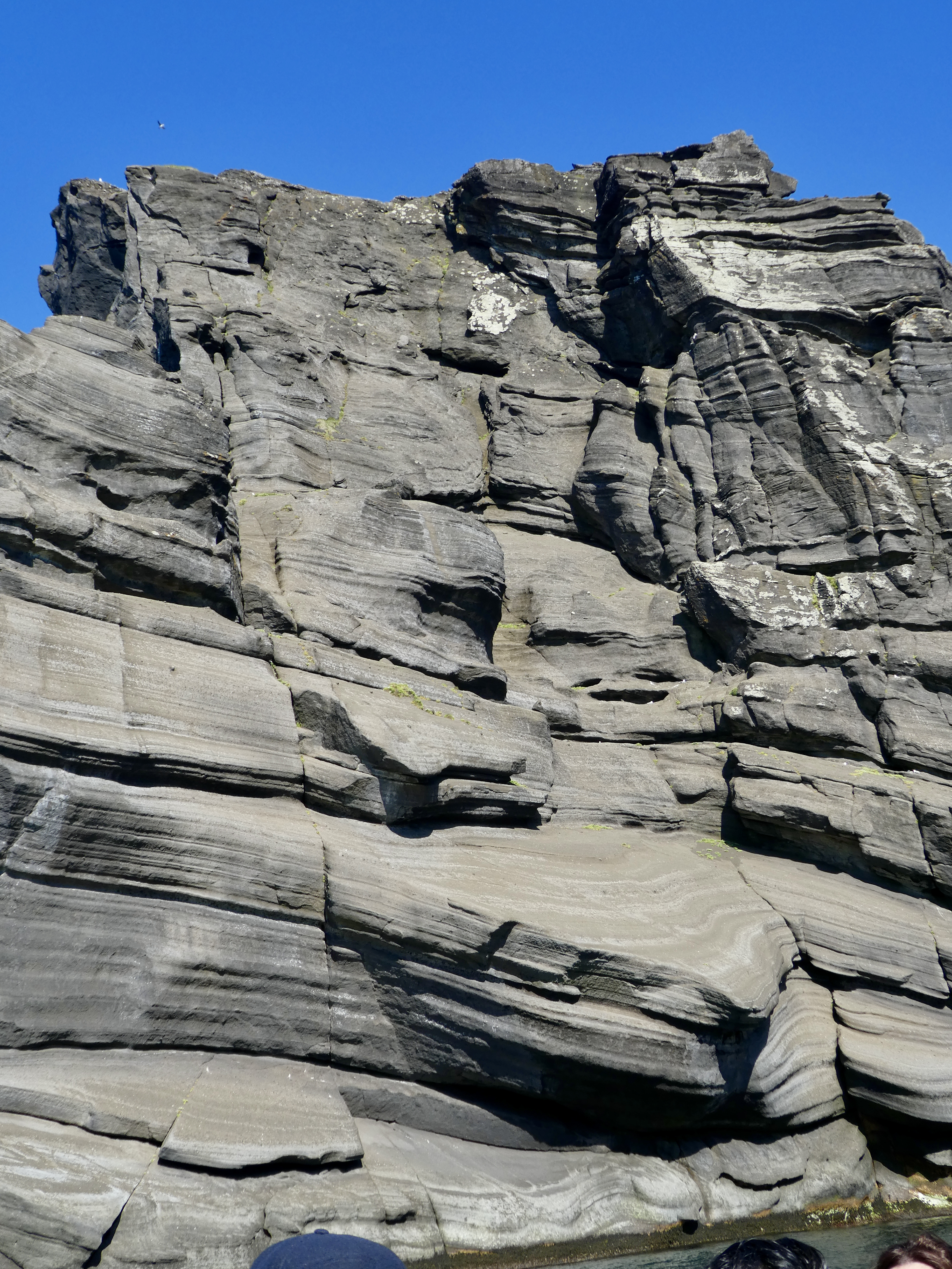
First, approaching the “bird cathedral,” you see a place without many ledges to give you an idea of the geology:
The birds:
These are nest sites! Look how crowded they are:
Less than a square foot per pair! They go out fishing, with one pair staying on the egg, so, as you cruise around, the air above is filled with thousands of wheeling, calling murres. See video below.
Two videos from the ride (filming was tough in a boat with nine other people, all trying to film or photograph):
Thousands wheeling above in the blue air:
This short video shows why I call it a “bird cathedral”. Truly a stunning site. A few days later we saw another murre cathedral on Jan Mayen Island.