Please send in your photos. I know some of you have them, and are too lazy to put them together! But remember the hours I put in here, which you can read FOR FREE. Isn’t it worth a half hour of your time to assemble some pictures? Guilt trip over.
Ephraim Heller went to Bhutan to for birding, and I’m extremely jealous! I swear I’ll get there one day. His notes are indented, and you can enlarge his photos by clicking on them.
My wife and I were lucky to have spent 2.5 weeks in April 2024 on a birding tour of Bhutan. Bhutan is a wonderful country with dramatic Himalayan scenery, unique Bhutanese architecture, a lovely Buddhist culture, and kind and open people. We saw >320 species of birds as well as numerous species of mammals, reptiles, bugs, and insects. I’ll share a series of posts containing photos of the species for which I was able to obtain decent pictures. I’ll also mix in a few landscape and architecture shots here and there, just to keep things interesting.
Bhutan stretches along the south face of the Himalayas from an altitude of 660 ft in the south along the Indian plain to more than 23,000 feet, creating an outstanding range of diverse ecosystems and biodiversity. This photo gives you a sense of the rugged terrain covering most of the country:

The country is divided into 20 districts each governed from a local “dzong,” which were originally designed as fortresses. Most dzongs today house both religious (Buddhist) and civil (government) administrations.

I’ll kick off this wildlife photo series with the Accipitridae (hawks, eagles, kites, and old world vultures). Descriptions of the species below are taken from Wikipedia.
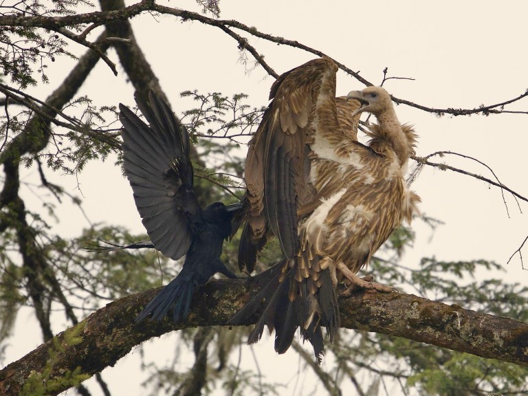
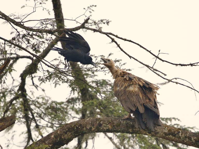
A Himalayan Griffon Vulture (Gyps himalayensis) is harassed by a Large-Billed Crow (Corvus macrorhynchos). The Himalayan Griffon is the largest of the Gyps species and is perhaps the largest and heaviest bird in the Himalayas. The weight of Himalayan vultures ranges from 6 kg (13 lb) to 12.5 kg (28 lb). They live mainly in the higher regions of the Himalayas and the Tibetan Plateau at the elevation range of 1,200–5,500 m (3,900–18,000 ft). On the Tibetan Plateau 64% of their diet is obtained from dead domestic yak (Bos grunniens). Historically, Himalayan vultures regularly fed on human corpses left out on Celestial Burial Grounds.
We saw a pair of griffons land, one in a tree and one on the ground. We watched for 15 minutes as a crow flew around the griffon in the tree to peck at its back and pull on its tail feathers:
Griffons and crows do not typically compete for food, so our guess for the crow’s behavior is that it was probably nesting nearby. The griffon did its best to face off with the crow and stand its ground, but the crow was not deterred:

We observed this Steppe Eagle (Aquila nipalensis) resting on a large rock in the middle of a river, probably during its migration. It, too, was periodically harassed by crows and other birds. The steppe eagle’s well-feathered legs illustrate it to be a member of the subfamily Aquilinae, also known as the “booted eagles”. This species was once considered to be closely related to the sedentary tawny eagle (Aquila rapax) and the two forms have previously been treated as conspecific. The steppe eagle is in many ways a peculiar species of eagle. It is a specialized predator of ground squirrels on the breeding ground, also taking other rather small mammals and other prey, doing so more often when ground squirrels are less consistently found. They are the only eagle to nest primarily on the ground. The steppe eagle undertakes a massive migration from essentially its entire breeding range, moving en masse past major migration flyways, especially those of the Middle East, Red Sea, and the Himalayas. Unfortunately, the steppe eagle’s population has declined precipitously:

The Crested Serpent Eagle (Spilornis cheela) is found in forested habitats across tropical Asia. They have a large looking head with long feathers on the back of the head giving them a maned and crested appearance. The face is bare and yellow joining up with the ceres while the powerful feet are unfeathered and heavily scaled. They fly over the forest canopy on broad wings and tail have wide white and black bars. They call often with a loud, piercing and familiar three or two-note call. They feed on snakes and lizards, giving them their name:

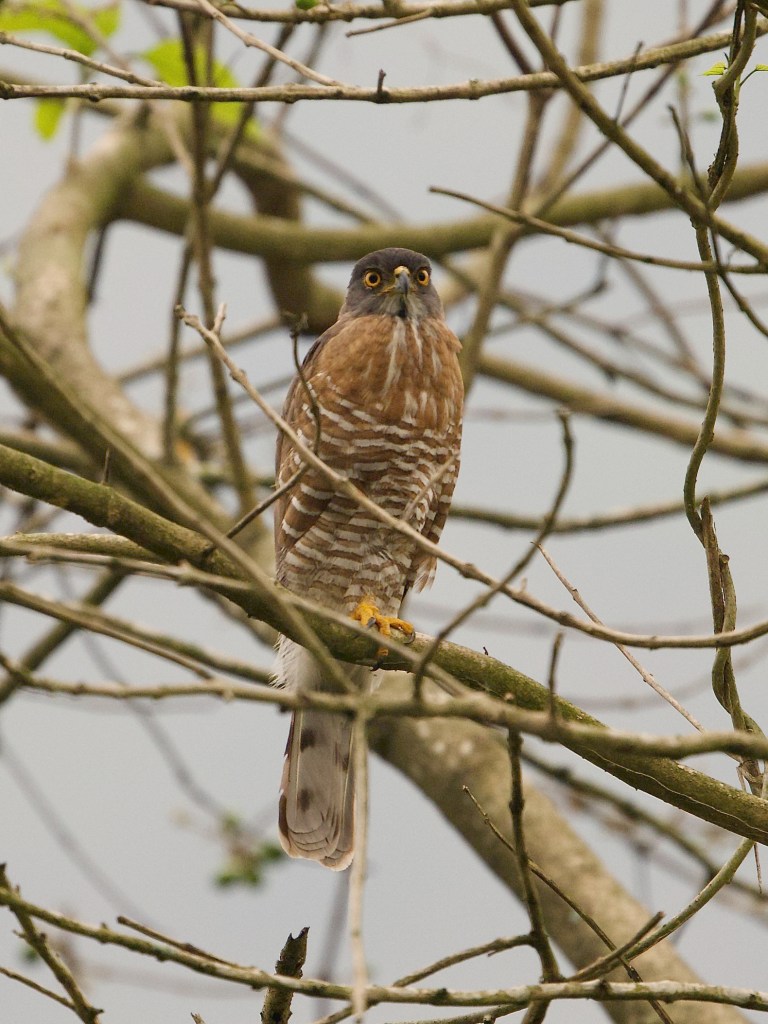
We observed this Crested Goshawk (Accipiter trivirgatus) in a tree, also being harassed by smaller birds (apparently it’s not so easy to be a raptor in Bhutan). It is primarily a lowland bird of warm climates, and is unusual at upland habitats in Bhutan. This secretive forest bird hunts birds, mammals, and reptiles in woodland, relying on surprise as it flies from a perch to catch its prey unaware:
Sometimes you’ve just got to scratch an itch:

This male Eurasian Sparrowhawk (Accipiter nisus) is a small bird of prey. Though it is a predator which specializes in catching woodland birds, the Eurasian sparrowhawk can be found in any habitat and often hunts garden birds in towns and cities. Males tend to take smaller birds, including tits, finches, and sparrows; females catch primarily thrushes and starlings, but are capable of killing birds weighing 500 g (18 oz) or more:

The Himalayan Buzzard (Buteo refectus). It was only on this trip that I learned that while buzzards are types of vultures in North America, in other parts of the world buzzards are types of hawks:

Equipment: All animal photos were shot using a Nikon Z9 camera and Nikkor Z 400mm f/2.8 TC VR S lens. Landscape and architectural photos were shot either with a Nikon Z9 and Nikkor Z 70-200mm f/2.8 VR S lens or with an iPhone 11.
You can see more of my photos at https://www.instagram.com/hellerwildlife/.
