Readers’ wildlife photos

February 16, 2026 • 8:15 am

Dean Graetz has come through with a set of images from the outback of Australia. His notes and IDs are indented, and you can enlarge his photos by clicking on them. Dean has added links to two videos, one of them his.

And send in your wildlife photos! Once again, this is the last batch I have.

Australian Landscape Images

Being geo-patriots, we frequently travelled and camped in the remote Australian Outback, aka ‘The Bush’, which is about 70% of the continental area.  Our interest was landscapes – their vista, and the living and fossil lifeforms they contained.  Here is a series of landscape photos chosen by their appeal summarised as one word.

Bliss

Dusk: Site chosen on extensive plain – see horizon.  A table set for two, one-saucepan meal on gas burner, and swags (bedroll) to be positioned and occupied last.  A near cloudless sky with dry airmass promises a dome of stars all night.  Bliss!:

Beginning

It is always entrancing to witness the silent illumination and transient colours of a landscape as our world turns to the Sun.  Always, you see detail and colours that you didn’t appreciate during the previous dusk.  This is a sandy bed of a large but ephemeral creek – a great campsite.  The stark, dead (Eucalypt) trees germinated with the 1974 floods only to be killed by a wildfire some 20 years later.  Such is life:

Reboot

A ‘Spinifex’ (actually Triodia) grassland wildfire: hot and lethal, reducing all in its path to ashes.  This hummock grassland type covers about 25% of the continent.  Ignited by lightning or people, such fires are frequent.  With the first rain post-fire, the Triodia regenerates from seed and roots, faster than competing woody plants.  So, repeated fires – burning your neighbours – is a sustainable way to persist:

Success

Heavy rains in 2009 triggered a massed pelican breeding.  Thousands of birds gathered at one location, mated and successfully bred.  More details are here.  Success in this time-dependent gamble is shown by the chicks (darker heads) are now as large as the parent birds.  All life is a Game: If you win , you stay in the Game:

Bugger

A feral camel (Dromedary [Camelus dromedarius] single hump) enjoying an uncommonly lush grassland.  Imported in the mid-1800s, camels facilitated the exploration and settlement of Outback Australia.  Displaced by motorized vehicles in the1920s, instead of a bullet, they were abandoned to die out.  But they didn’t.  Then a couple of hundred camels is now a large feral population of at least 600,000 damaging pests – a significant multi-million dollar problem.  In the Southern Hemisphere, a well-intentioned action resulting in a disastrous outcome is widely known as a Bugger, made famous by this Toyota video:

Mute

A rock engraving, a graphic message from a pre-literate time, meticulously pitted on a vertical rock face.  What can be inferred from it?  In order of certainty, it was done by a male, likely over a working period of 3-5 days, at least 10,000 years ago.  In spite of much speculation, we cannot ever really know the message or the audience, a realization that sometimes evokes a puzzling tinge of sadness:

Harsh

The Pilbara region is Australia’s harshest landscape.  It is hot –(recorded 160 consecutive days of above 100°F (38°C)), and essentially water- and treeless, and rendered unfriendly by the swarm of small spiny hummocks of Spinifex (Triodia).  Yet prospectors and geologists continue to search here for mineral riches.  After we found the rocks containing a fossil stromatolite, dated at 3.4 billion years, and then thinking about Deep Time, we forgot about the current temperature and Spinifex spines:

Serenity

Why do we find a slow-flowing river so timeless, relaxing and peaceful?  In 1925, two men, Jerome Kern and Oscar Hammerstein, wrote their explanation as the words of the song ‘Old Man River’.  A truly timeless contribution to our culture that you are probably silently singing right now:

Awe

This image captures a mind-stretching contrast in ages between the biological world and the geological world.  In the foreground are several species of ephemeral  plants – bright, colourful, with a life spans of months to a year or so.  In the background, the blood red rocks looking sharp edged and resistant, are dated at more than 2.5 billion years.  The smallest units of geological dating, millions of years, are beyond the reckoning of biologists, yet life was present on earth when those background rocks were being formed.  The Deep Time of Life is right up there with the Rocks:

Me

A densely painted gallery in Arnhem Land, northern Australia.  The gallery contains older figures – devil-devil figures (LHS), a python and several crocodiles (Middle) – all overpainted by numerous, modern (less than 100 years) ‘hands’.  The ‘hands’ are not stencils or imprints.  They are deliberate drawings infilled with colour.  The overall impression of the modern ‘hands’ layer is just exuberant happiness celebrating ‘Me’, ‘Look at Me’, by the many painters who contributed.  No deep cultural significance just an expression of the ‘joy of life’ in vivid colour.  The longer you scan this image, the more surely you will smile:

Renewal

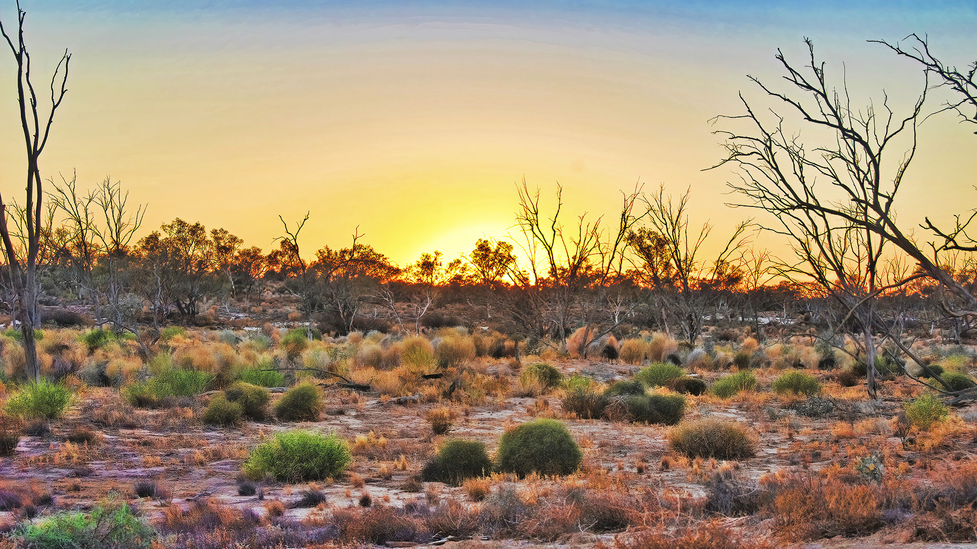
It was a hurried camp selected in falling light with the best site option being a desert track in the sea of (flowering) Spinifex.  All that is forgotten now as you slowly wake in the golden light of a quiet and calm dawn, along with the smell of dew-dampened sand.  Life is good!:

Readers’ wildlife photos

November 12, 2025 • 8:15 am

We’re down to one more contribution, and then the tank runs dry. Please send in your GOOD photos, preferably a related group instead of singletons.

Today’s penultimate photo-and-text post comes from Athayde Tonhasca Júnior, and is part III of a series of his visit to a park in Brazil (see parts 1 and 2 here and here). Athayde’s captions are indented, and you can enlarge his photos by clicking on them.

Chapada Diamantina – III

About 70 km from Lapa Doce, we arrive at Lençóis (len-soh-iss), the main gateway to Chapada Diamantina National Park.

The village of Lençóis was established around 1845 with the discovery of diamonds along the Lençóis river (pictured) and other watercourses in the region. This was a magnet to adventurers, deserters, runaways, visionaries, petty criminals, big criminals, women of ill repute, preachers, government officials and other ne’er-do-wells. Like any hard work carried out during most of Brazilian history, diamond panning was done by slaves, who built the bridge over the river:

Between 1845 and 1871, Lençóis was the world’s largest diamond producer. At the height of its wealth, the town had a cinema, two newspapers and a French vice-consulate. Here, the former residence of a local nabob:

Things become to unravel in the 1860s, with the progressive depletion of diamonds. But the death knell came in 1865 with the discovery of diamonds in South Africa. Most people left and the town quickly fell into decay. Fortune turned again in the 1990s when outsiders discovered the region’s natural beauty. Today, luxury hotels, B&Bs, dozens of tourism agencies and restaurants cater to national and foreign tourists:

A view of Chapada Diamantina National Park. The 152,000-ha park was created in 1985 with the help of American biologist Roy Funch, who arrived in the area in 1978 and still works as a local guide. The park comprises caatinga xerophytic formations, cerrado (a type of tropical savanna) Atlantic Forest vegetation, meadows and rocky plateaus (chapadas):

Detail of lithophytes (plants that grow on bare rock) on a plateau top. This local flora has high degrees of diversity and endemism, but it is still poorly known. An open field for a beginner botanist:

Most park visitors head for the waterfalls and natural pools (of outstanding beauty), but we wanted to explore the caatinga, a UNESCO designated biosphere reserve and one of the world’s less studied biomes. All the ‘dead’ vegetation in this photo will spring to life at the first seasonal rainfall:

These two cacti are some of the caatinga‘s most ubiquitous sights: mandacaru (Cereus jamacaru) on the left, and xique-xique (Xiquexique gounellei). They both look disagreeable desert denizens to be kept at arm’s length, but there’s more to them than their sharp, painful thorns. These cacti are important fodder for cattle, goats and sheep in times of water scarcity (they are scorched slightly before being given to animals). Mandacaru‘s fruit feeds humans and wildlife, and its woody stem is valued in carpentry for its resistance to termites. Xique-xique flour can be added to goat’s milk for the production of yogurt with supposedly better probiotic quality:

This ‘stone’ is a tuber of a umbuzeiro tree (Spondias tuberosa), a natural water reservoir. The tuber network of a single tree can store up to 3,000 l of water during the dry season. The umbuzeiro fruit is consumed by wildlife and humans, and it’s sold in local markets:

We wrap up with a moqueca (moh-keh-kah), a seafood stew (fish or prawns) that is a must in the Brazilian cuisine and that best reflects its African, native American and Portuguese heritages. There are regional variations, but this moqueca was made with fish in a base of tomatoes, peppers, onions, garlic, palm oil and coconut milk. Urucum (Bixa orellana) pigment was added for colour, and chopped coriander sprinkled on top. Served with rice, pirão (a thick cream made with cassava flour and fish stock) and farofa (toasted cassava flour, onions, spices and nuts from a local palm tree). A fabulous dish from Nega and Jéssica, owners of Duas Irmãs (two sisters) restaurant.

After a gruesome 420-km drive dodging colossal potholes and nihilistic, homicidal motorists, we arrived back to Salvador, Bahia State’s capital and Brazil’s capital until 1763. The city is rich in cultural traditions, but like in any of the country’s big cities, you’d better mind your wallet, phone, empty alleys and overtly friendly strangers. As the natives say, Brasil não é para amadores – Brazil is not for amateurs:

Readers’ wildlife photos

November 7, 2025 • 8:15 am

I’m running pretty low folks, so if you have good wildlife photos, perhaps you’d like to collect them, write a bit of text, and shoot them my way. Thanks.

Today we have another photo-and-text journey from Athayde Tonhasca Júnior. This is part II, and you can find part I here, which explains the region.  Athayde’s captions are indented, and you can enlarge the photos by clicking on them.

Chapada Diamantina – II

We continue our journey inside Lapa Doce.

There’re lots of water stored in pools, nooks and crevices in all these cave networks. This water was vital to local populations before wells and distribution systems arrived. The doce of Lapa Doce is an allusion to água doce (sweet water), the Portuguese term for ‘fresh water’. These waterbodies are home for all sorts of creatures, including the endemic, blind and albino catfish Rhamdiopsis krugi:

Many skeletons of extinct creatures such as saber-tooth tigers, prehistoric armadillos, horses, and giant sloths have been found on the ancient riverbed. Here, a Eremotherium laurillardi giant sloth is flanked by a 1,80 m human:

The Scream II:

Everywhere: the relentless destructive/constructive action of water:

In some thousand years, this stalactite and stalagmite will come into contact and fuse into a column. You can’t see it from pictures taken by phones under torchlight, but mineral water is dripping ever so slowly from the tip of the stalactite:

The end of the trail, through another collapsed doline. Back to a world of blinding light and sizzling temperatures:

Some of the hundreds of cave paintings found on the walls of collapsed dolines in the region. They have not been dated, we know nothing about the artists, which didn’t stop wackos infesting the internet with extraterrestrial theories:

These cavities under the cave projection look like the result of water drips, but looks are deceiving. Each hole is a trap. A careless insect falling in will try to climb out, dislodging soil particles that send sensory signals to a predator buried on the bottom of the pit– an antlion larva, a lacewing-related insect (family Neuroptera) that will seize the prey, inject it with venom and suck up its innards:

Danger, danger everywhere. An apparently benign bank along the trail…:

… is an ideal ambushing spot for a trapdoor spider (infraorder Mygalomorphae). The door is a hinged segment of a silk cocoon that hides a patient spider:

Readers’ wildlife photos

November 2, 2025 • 8:15 am

Athayde Tonhasca Júnior is back with a photo travelogue—the first of three parts.  Athayde’s captions are indented, and you can enlarge the photos by clicking on them.

Chapada Diamantina, Part I

Last year I invited WEIT readers to join me in a photographic tour of Serra da Capivara, a spectacular national park sited deep in the Brazilian caatinga, a semi-arid ecosystem that hosts exceptional levels of biodiversity and endemism. Today we will visit another ecological gem in the same geographical region: Chapada Diamantina, a 38,000 km2 expanse of rocky plateaus (chapadas), caves, forests, caatinga, grassland and savanna in Bahia State.

Chapada Diamantina region, northeastern Brazil © Ferrari et al., 2009:

We begin at Lapa Doce, or Sweet Cave, located in the municipality of Iraquara, the ‘speleological capital’ of Brazil. There are 1,694 cave systems in the region: one of them, Toca da Boa Vista, is the longest cave in South America, extending for 114 km. Lapa Doce is part of a 42-km network of caves, many yet to be explored and mapped; a ~1 km segment is open to guided visitation.

The cave’s entrance is hidden at the bottom of this collapsed doline (a bowl-shaped depression formed by dissolved limestone), aka sinkhole. Note the ribbed rock surface, a telltale sign of an oceanic past:

The bottom of the doline with a typical karst formation (a landscape largely shaped by water-dissolved rock). The temperature here is considerably cooler than at ground level:

The ‘melting’ effect of water on carbonate rocks:

This sign along the path to the cave precludes blaming language barriers for inappropriate behaviour inside the cave:

Cave entrance on the right. The two figures in red are human-size dummies planted there to give us a sense of scale:

Into the cave. The path is flanked by outlandish formations such as this floating jellyfish, illuminated by our three torches:

A monster from the underworld. By slowly swinging his torch up and down, our guide Raimundo made it open and shut its maw:

Lapa Doce was formed by a subterranean river that carved the limestone. The gallery is 60 m wide and 25 m high at the widest points:

If your torch goes kaput, you will need to use the rope that borders the path (seen on the bottom right) to guide you out. With no artificial light the darkness is absolute and disorientating:

Readers’ wildlife photos

August 18, 2025 • 8:15 am

Thanks to the readers who sent in wildlife photos.  Today we have the first part of a two-part series from Kevin Krebs taken in British Columbia. Kevin’s notes and IDs are indented, and you can enlarge the photos by clicking on them.

The Crowsnest to Osoyoos – Part 1

Vancouver to Princeton

Each spring I make a pilgrimage from my home in Vancouver to Osoyoos in south-central British Columbia. Birds are what drew me there initially, but over the years the ecology and geology have cast a spell on me.

After roughly 2½ hours of driving on the Crowsnest Highway, E.C. Manning Provincial Park is my first stop. Located in the North Cascades, the area is densely forested with coniferous trees, and even in late May you can expect to find some patches of snow.

Every year without fail I’m greeted by numerous Columbian Ground Squirrels (Urocitellus columbianus). They hibernate for up to 8 months of the year, and this population has probably been active for only a few weeks when I visit.

I don’t have to go much further than the parking lot to find flocks of Chipping sparrows (Spizella passerina).

Venturing further into the park, I almost always find a few Townsend’s Warblers (Setophaga townsendi).

This year I felt especially lucky — a pair of American Three-toed Woodpeckers (Picoides dorsalis) appeared out of nowhere just as I was about to leave.

Princeton is my next stop, and where the transition from the forests to semi-arid climate begins to become apparent. According to Wikipedia, “Princeton is one of the sunniest places in British Columbia with 2,088 hours of sunshine annually”.

My destination is Swan Lake Wildlife Refuge, located just north of the city that is always replete with swallows, waterfowl, and many other surprises.

A Common Raven (Corvus corax) keeping watch from a fence post.

New World Sparrows (Family Passerellidae) don’t get a lot of love and it’s not uncommon to hear them derided as LBJs (Little Brown Jobs). I think many birders do themselves a disservice by not paying attention to sparrows and other ‘common’ birds. Here’s a beautiful Vesper Sparrow (Pooecetes gramineus) posing on a branch.

American Kestral (Falco sparverius) are the smallest and most widespread North American falcon with distinctive sexual dimorphism. This male was waiting out a sudden rain shower:

Another photo of the American Kestral (Falco sparverius) being scolded by a Western Meadowlark (Sturnella neglecta) who was very unhappy with his presence:

The bluest of bluebirds — this male Mountain Bluebird (Sialia currucoides) was quite shy, but let me get a decent photograph before it fled my primate curiosity.

A mediocre photo of a Lewis’s Woodpecker (Melanerpes lewis) — a large, oddball woodpecker which is still somewhat enigmatic.

On the route to Osoyoos, I pass through the small town of Hedley, once the site of a gold mine (confusingly named the Nickel Plate Mine). The geology is striking — uplifted Triassic sedimentary rocks of the Nicola Formation.

The Golden Circle: three notable spots in Iceland

July 23, 2025 • 7:45 am

Yestday I took an eight-hour bus tour to see the famed “golden circle” of tourist sights near Reykjavic in Iceland.. Wikipedia delineates what we saw:

The Golden Circle (IcelandicGullni hringurinn [ˈkʏtlnɪˈr̥iŋkʏrɪn]) is a tourist route in southern Iceland, covering about 300 kilometres (190 mi) looping from Reykjavík into the southern uplands of Iceland and back. It is the area that contains most tours and travel-related activities in Iceland. The term for the “Golden Circle” was a marketing tactic developed by the Icelandic Tourism board to improve travel.

The three primary stops on the route are the Þingvellir National Park, the Gullfoss waterfall, and the geothermal area in Haukadalur, which contains the geysers Geysir and Strokkur, which erupts every 10-15 minutes. Though Geysir has been mostly dormant for many years, Strokkur continues to erupt every 5–10 minutes. Other stops include the Kerið volcanic crater, the town of HveragerðiSkálholt cathedral, and the Nesjavellir and Hellisheiðarvirkjun geothermal power plants.

Below is a map from Always Around the World of the route we took, which involved about 7.5 hours of total travel and 270 km of driving. Sadly, we went by Keri∂ Crater (a sunken volcanic crater filled with an emerald-green lake), but didn’t have time to see it. We did, however, see lots of the Icelandic countryside, which is flat and grassy, both because it comprises farms but also because the terrain has been flattened by glaciers and the climate is not conducive to trees.

The three sights we visited were Thingvellir National Park, the site where the conjunction of two tectonic plates is most obvious in the world, Geysir, an area of geothermal activity with, yes, geysers, and Gullfoss, one of the most beautiful waterfalls I’ve ever seen (I haven’t been to Niagra).

First, the rift park:

Þingvellir (Icelandic: [ˈθiŋkˌvɛtlɪr̥], anglicised as Thingvellir) was the site of the Alþing, the annual parliament of Iceland from the year 930 until the last session held at Þingvellir in 1798.  Since 1881, the parliament has been located within Alþingishúsið in Reykjavík.

Þingvellir is now a national park in the municipality of Bláskógabyggð in southwestern Iceland, about 40 km (25 miles) northeast of Iceland’s capital, ReykjavíkÞingvellir is a site of historical, cultural, and geological significance, and is one of the most popular tourist destinations in Iceland. The park lies in a rift valley that marks the crest of the Mid-Atlantic Ridge and the boundary between the North American and Eurasian tectonic plates.

I saw no remnants of its parliamentary history, but was delighted to see the signs of the two tectonic plates. I don’t know of any other place on Earth where their conjunction is so obvious. They are moving apart now, at about the rate your fingernails grow: about 1 cm per year.  This movement has created a wide valley containing lake as well as numerous cracks in the earth created as the plates separate. These fissures are all parallel, running from northeast to southwest.

Here’s the rift valley, which we were told is abut 7 km across. You can see the mountains on the other side and the lakes in the valley, while I took the picture from above, on the North American plate:

Here are a few of the fissures in the ground nearby:

This is a big one that people walk through. I have to add that, according to our guide, this was the busiest tourist day this summer. Although it was a Monday, it was sunny and warm: 23º C (73.4° F), and I quickly took off all my outer layers except for a tee-shirt. As you can see below, there were tons of tourists about. It’s summer, July and August are vacation months for the locals, and many of the visitors were Icelandic.

Regardless, I was tremendously excited to see the actual results of plate tectonics, though I’ve seen them before (e.g., the Himalayas). But actually standing on an area where the plates are moving apart was, at least for me, a huge thrill.

On to Haukadalur with its geothermal activity and geysers (I’ve never seen a geyser although the U.S. has the famous “Old Faithful” in Yellowstone National Park).

The geothermal activity is clear even from the parking lot of the visitor center.  Many of these small craters emitting steam also have bubbling hot water. (I have video but can’t post it here; more later.) There are ample warnings to stay away from the water, which is 80-100°C.

Below: the Icelandic geysers compared to others in the world. “Geysir,” the biggie, is no longer active, but Strokkur is, and erupts irregularly with an average about ten minutes. You can see the Strokkur isn’t that much smaller than Old Faithful, but Geysir, when it was active topped them all. I saw about four eruptions of Strokkur (see below). Old Faithful in the U.S. erupts about 20 times a day.

When I asked my guide where the big geyser was, she responded, “Just walk into that area. You’ll know.” And, sure enough, I did:

These people are waiting for Strokkur to erupt, which, as I said, does so irregularly with a mean of about ten minutes.  Because the eruption takes only a second or two, you have to be ready, and it does tire your arms to hold your camera up, focused on the likely eruption spot. I got three shots, with the last missing the top of the largest eruption. It’s a pretty impressive sight (these are three separate eruptions):

And the biggie (I wasn’t prepared for the height):

This is a good YouTube video of what it’s like to be in the area and see the eruptions:

Despite the heat and sulfur, plants and moss grow near the hot effluent. Life is tenacious. Here’s one photo:

Finally, the waterfalls of Gullfoss, as explained in the sign below. Originally it was to be made into a hydroelectric plant, but the locals saved it. Now it’s part of a permanent conservation area:

From Wikipedia:

The Hvítá river flows southward, and about a kilometre above the falls it turns sharply to the west and flows down into a wide curved three-step “staircase” and then abruptly plunges in two stages (11 metres or 36 feet, and 21 metres or 69 feet) into a crevice 32 metres (105 ft) deep. The crevice, about 20 metres (66 ft) wide and 2.5 kilometres (1.6 mi) in length, extends perpendicular to the flow of the river. The average amount of water running down the waterfall is 141 cubic metres (5,000 cu ft) per second in the summer and 80 cubic metres (2,800 cu ft) per second in the winter. The highest flood measured was 2,000 cubic metres (71,000 cu ft) per second.

As it was a rare day of full sun, I had the luxury of seeing a rainbow at these lovely falls. The roar is impressive, and the falls go down in several steps.  I have video but again you’ll have to wait to see that. But I’ve put a video below. First, a few photos I took of the falls. Notice the rainbow (and plethora of tourists):

Here’s a video which gives you a sense of what it’s like to be near this enormous waterfall: Even a gazillion tourists couldn’t drown out the roaring:

A plant I photographed nearby. Botanists: what is it?

And three superfluous photos. First, a teeshirt in the gift shot at Gullfloss (all the tchotchkes are the same in all the shops). Notice the accuracy: the third puffin, which is Paul on the Abbey Road cover, is barefoot, just as Paul was:

Yesterday’s gull levitating a roll with its bill. The gull must have been magical:

And my post-trip reward: ice cream (hazelnut and crème brûlée).  Guess what it cost? But, as Hemingway would say, ‘I deserved it, and it was good.”

To Jan Mayen

July 15, 2025 • 8:00 am

Our destination is isolated Jan Mayen Island, home of the world’s most notherly active volcano (the last eruption was 1985). From Wikipedia:

For some time scientists doubted that the Beerenberg volcano [JAC: the big one in the pictures; there are two others] would become active, but in 1970 it erupted for about three weeks, adding another 3 km2 (1.2 sq mi) of land area to the island. It also erupted in 1973 and 1985. During an eruption, the sea temperature around the island may increase from just above freezing to about 30 °C (86 °F).

A nice warm bath! That’s the only thing that would persuade me to take the infamous “Polar Plunge”, a staple of Arctic and Antarctic cruises. You put on your bathing suit, tether yourself to a rope, and then jump into the sea emitting a porcine squeal as you hit the freezing water (3 degrees C).  Half of the passengers did this, which I see as a bizarre form of braggadocio and masochism. However, you do get a nifty badge for your efforts.

Jan Mayan appeared, as if by magic, early this morning, and is the only bit of land for hundreds of km around. Here’s its location from a CIA map given on Wikipedia. I’ve added the arrow. It’s a two-day sea voyage SW of Svalbard:

The island is spoon-shaped, with the spoon part containing the big volcano and its effluent:

. Like Svalbard, it’s also also Norwegian, and is often lumped together with the archipelago.  It has no permanent inhabitants but plenty of gravel. We were told at last night’s briefing that there are 18 inhabitants, most of them members of the Norwegian military, but also two meteorologists. There’s also a gift shop that will be open for our arrival; I’m curious to see what they are selling.

Most ships are not allowed to land there, but with some clever bargaining on the part of our expedition leader, we were given permission to land this afternoon.

As Wikipedia notes:

Jan Mayen (Urban East Norwegian: [jɑnˈmɑ̀ɪən]) is a Norwegian volcanic island in the Arctic Ocean with no permanent population. It is 55 km (34 mi) long (southwest-northeast) and 377 km2 (146 sq mi) in area, partly covered by glaciers (an area of 114.2 km2 (44.1 sq mi) around the Beerenberg volcano). It has two parts: larger northeast Nord-Jan and smaller Sør-Jan, linked by a 2.5 km (1.6 mi) wide isthmus. It lies 600 km (370 mi) northeast of Iceland (495 km [305 mi] NE of Kolbeinsey), 500 km (310 mi) east of central Greenland, and 900 km (560 mi) northwest of Vesterålen, Norway.

The island is mountainous, the highest summit being the Beerenberg volcano in the north. The isthmus is the location of the two largest lakes of the island, Sørlaguna (South Lagoon) and Nordlaguna (North Lagoon). A third lake is called Ullerenglaguna (Ullereng Lagoon). Jan Mayen was formed by the Jan Mayen hotspot and is defined by geologists as a microcontinent.[2]

Although administered separately, in the ISO 3166-1 standard, Jan Mayen and Svalbard are collectively designated as Svalbard and Jan Mayen, with the two-letter country code “SJ”. It was also given the web domain of .sj. However, the domain is not in use and Norway’s .no is used in its place.

Jan Mayen is home to Beerenberg, which is the northernmost subaerial active volcano in the world.[3][4]

And one more factoid (two, actually; bolding is m):

Jan Mayen Island has one exploitable natural resource, gravel, from a site located at Trongskaret. Other than this, economic activity is limited to providing services for employees of Norway’s radio communications and meteorological stations located on the island.

GRAVEL!

And, as Poseidon Adventures notes:

Though it is an integral part of the Kingdom of Norway and there are people living on the island year round, there is no way for a tourist to get to Jan Mayen other than by cruise ship or yacht. Though the island’s stunning scenery and abundant birdlife would easily place it among the world’s top wilderness tourism destinations, only a few hundred people make it to the island each year because of the infrequency of cruises.

We are 180 of those lucky people.  Here are some photos of the Beerenberg Volcano taken from the ship a few minutes ago. We are approaching from the north. Since I have better internet now, the resolution is higher (I had to degrade them by only about 55%). The volcanos arose because the island sites on a number of intersecting fault lines and on the mid-Atlantic ridge.

From inside the ship:

And on the ship’s bridge navigation pane, which is duplicated in the lounge. The position of the ship is the circle, and Jan Mayen is to the south:

Closer in as we pass down the west side of the island to the landing harbor. Note the snow cloud blowing off the peak:

A close-up of the peak and its blowing snow:

. . . and the view from my cabin. I can’t nap when there’s something like this right out the window.

More, of course, after we land and when I get a chance to put in proper photos. What kind of plants and animals will we encounter after our landing. Will I see a puffin? What’s in the gift shop? There are many lingering questions.