We start the new year with clouds, which, though some say they’re loaded with bacteria (and created by the bacteria as a means of dispersal), we’ll consider nonliving atmospheric phenomena. This montage could be called, “I’ve looked at clouds that way,” and comes from reader David Jorling in Oregon. David’s captions are indented, and the photos can be enlarged by clicking on them.
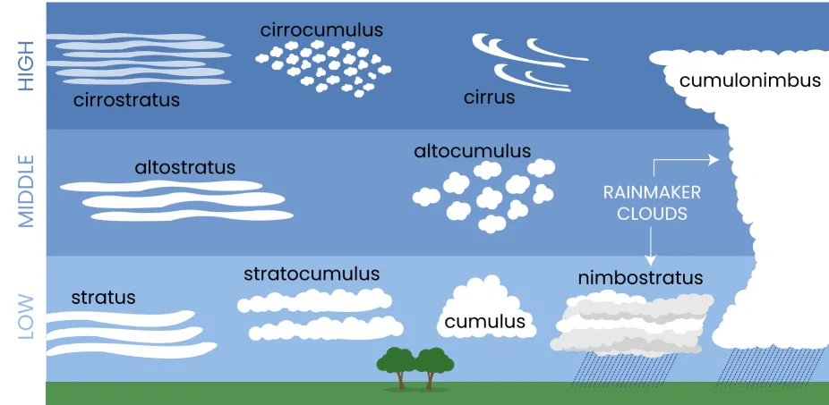
First of all here is an overly simple chart that I used to identify the clouds:
As to these three photos, the first was taken at Mary S Young State Park while I was walking my dog. These are “cirrus” clouds which, as I understand it, means there are strong winds in the upper atmosphere:

As to the following two pictures, which were taken from my yard amongs the Douglas Fir Trees. My best guess (and perhaps one of your readers has more expertise is that these are a mixture of cirrostratus and cirrocumulus clouds. perhaps in a state of transition:

More pictures taken from my yard. Again my best guess as is cirrrostratus clouds:

Perhaps these are in transition from cirrostratus to cirrus:

My suspicious is that these are Cirrostratus transitioning to cirrus:

This one was taken at sunset near Timberline Lodge on Mt Hood. They may have appeared lower perhaps because I was at about 6000 feet elevation instead of about 300 feet where I live. So my suspicion is that these are either cirrocumulus or altocumulus clouds:

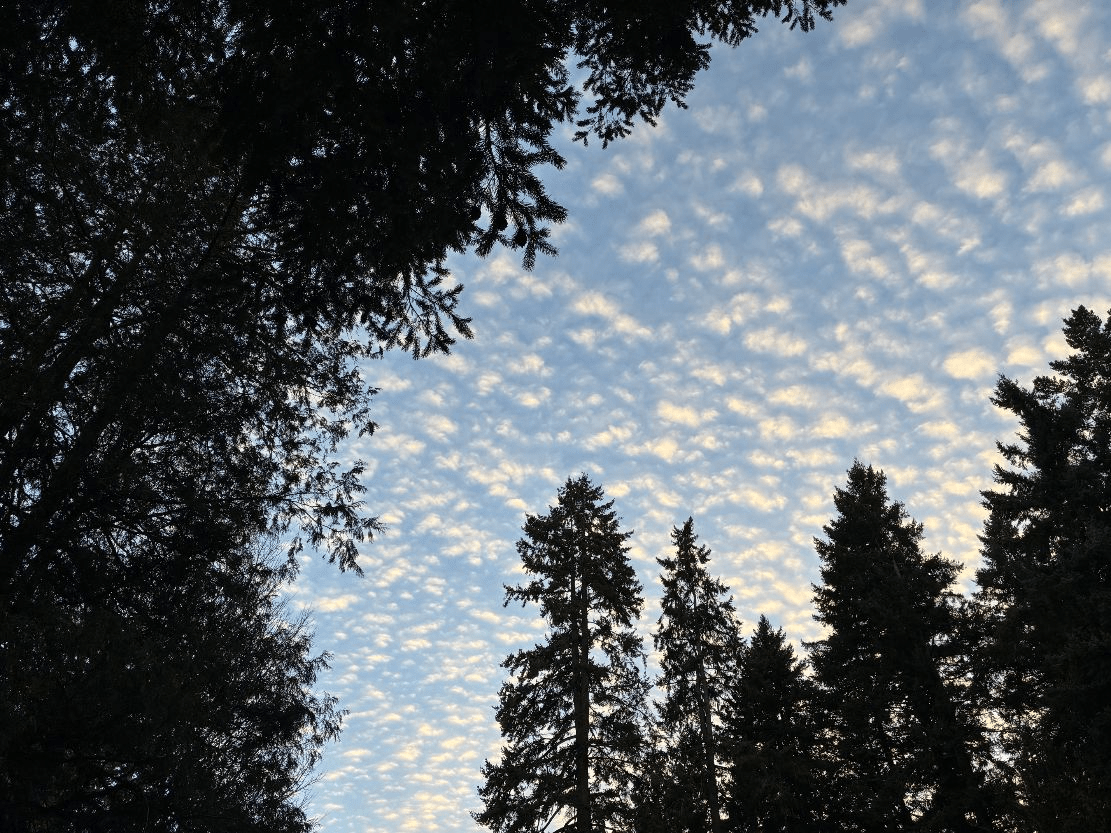
This is a picture from my yard toward some neighboring Douglas Firs and assorted evergreens. I suspect these are cirrocumulus clouds:
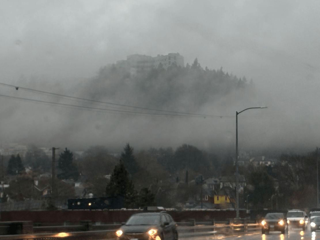
This is a picture I took from my car during a nationally forecast “Atmospheric River”. (In Oregon we call it “Rain”.) The picture was taken westbound on the Ross Island Bridge. The building above the Stratocumulus cloud (in Oregon we call it a “Fog Bank”) is one of the buildings of the Oregon Health Sciences University, which is the main medical school in Oregon:
Since you mention bacteria in the clouds, I’m reminded to recommend this excellent book that was published in 2025, all about the gradual scientific discovery of microbial life in the air: “Airborne,” by Carl Zimmer. It starts with the ancients and “miasma” theory, and covers all the way up through the difficulty of getting people to understand that COVID is airborne (not droplets or fomites). Really interesting history.
I have not heard about the idea that bacteria are a causal agent for clouds. On the other hand, don’t fine airborne particles lower the threshold where water in the gaseous state starts to precipitate into a visible water vapor?
Yes, small particles act as condensation nuclei. That’s the principle behind “cloud seeding”.
See https://en.wikipedia.org/wiki/Cloud_condensation_nuclei for more.
I like this variation on the theme of Wildlife Photos!
I’ve noticed only recently that, gee, do I perceive a slight prism effect in some lighter clouds, as here? If I let the eye acclimate to the light, it seems some greens, oranges, are coming through … mixed with the other scattering (e.g. Mie scattering, being white forward scatter).
I noticed this too :
“cirrrostratus”
Which I quite like! Perhaps even better :
Cirrrrrostratus
😁
Nice pictures of things so familiar that we rarely even look.
I have several files of cloud photos because I paint landscapes and they give me inspiration. I look for interesting, but not so interesting they become the total focus. There are some very nice ones here.
We don’t look up enough.
Why don’t you photograph one of your landscapes for a “wildlife photo” submission? There always seem to be a shortage.
Late last night, looking at the weather map for what was heading toward Pittsburgh there were two formations coming down generally across the Great Lakes. One, traveling much faster, overtook the other but didn’t subsume it. I had never seen anything like that before.
That atmospheric river is called a mackerel Sky in the UK as it looks loke a mackerel’s skin. A harbinger of rain to come.
Nice pix and a breath of fresh air for the new year. Thanks!
I love these! Thanks for posting them.
Nice, especially the sunset! Thank you.
“Atmospheric River” Up here in Western Washington, I only remember hearing that term recently, and now every year we have at least one. What was once dubbed “the pineapple express,” heavy rains coming from the warm waters/atmosphere of Hawaii (I gather the entire Pacific region thereof) is now an atmospheric river. I prefer the old nomenclature.
One of our Nasa atmospheric scientists used clouds as the focus of a wonderful citizen science program for K12 kids. Clouds were obvious to all without special equipment; they held lots of chemistry and physics; everybody sees the same thing at the same time; their patterns affect our daily lives. Her program inspired and enlisted lots of kids across the grades.
Just adding the website to the citizen science clouds program, part of GLOBE. Url should be
https://www.globe.gov/web/s-cool
Though I do need to say that I do not know if program is still active. My last contact with them was around 2012. Website is still active it appears.
Love the chart showing the different types of clouds and their elevations. I leared a lot!
You’ve captured some really interesting clouds. I’d love to see more unusual clouds, if anyone has them. Anyway, thanks for sharing them!
Lovely, thank you!
Now that we have access to meteorology apps and websites (I subscribe to Windy) there are always opportunities to geek out on all kinds of phenomena. I like the “atmospheric river” term except that TV meteorologists mention it only when it rains a LOT. But if you look at satellite pictures, they are commonplace any time warm oceanic air decides to take a trip toward one of Earth’s poles.
Yes yes, the Oregon clouds. In western Oregon one develops a fine appreciation of shades of green and gray.